IMAGES TAKEN NEAR TO
Mount Pleasant Estate, ABERTILLERY, NP13 2HW
Introduction
This page details the photographs taken nearby to Mount Pleasant Estate, NP13 2HW by members of the Geograph project.
The Geograph project started in 2005 with the aim of publishing, organising and preserving representative images for every square kilometre of Great Britain, Ireland and the Isle of Man.

There are currently over 7.5m images from over14,400 individuals and you can help contribute to the project by visiting https://www.geograph.org.uk
Image Map
Images are licensed for reuse under creativecommons.org/licenses/by-sa/2.0
Notes
- Clicking on the map will re-center to the selected point.
- The higher the marker number, the further away the image location is from the centre of the postcode.
Image Listing (8 Images Found)
Images are licensed for reuse under creativecommons.org/licenses/by-sa/2.0
Image
Details
Distance
2
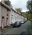
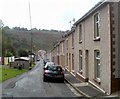
Northern section of Hafodarthen Road, Llanhilleth
Looking north from number 57.
Image: © Jaggery
Taken: 6 Oct 2011
0.16 miles
3
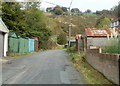
Lock-up garages near the northern end of Hafodarthen Road Llanhilleth
Image: © Jaggery
Taken: 6 Oct 2011
0.16 miles
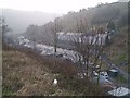
5
Looking SW along Hafodarthen Road, Llanhilleth
There is a two or three metre break in the terraced housing on a bend in Hafodarthen Road.
The gap at the right edge of the view is between number 55 and number 57.
Image: © Jaggery
Taken: 6 Oct 2011
0.21 miles
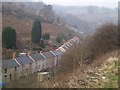
6
View towards Brynithel from Trinant
From this http://www.geograph.org.uk/photo/5234338 bench
Image: © Jaggery
Taken: 19 Dec 2016
0.21 miles
7
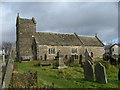
St Illtyds Church
Reported to be the oldest building in NW Gwent
Image: © phil matthews
Taken: 20 Jan 2006
0.21 miles
8

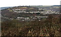
Brynithel from the air
Viewed from a Bristol bound flight from Glasgow.
Image: © Thomas Nugent
Taken: 11 Oct 2010
0.21 miles