IMAGES TAKEN NEAR TO
NP13 2ER
Introduction
This page details the photographs taken nearby to NP13 2ER by members of the Geograph project.
The Geograph project started in 2005 with the aim of publishing, organising and preserving representative images for every square kilometre of Great Britain, Ireland and the Isle of Man.

There are currently over 7.5m images from over14,400 individuals and you can help contribute to the project by visiting https://www.geograph.org.uk
Image Map
Images are licensed for reuse under creativecommons.org/licenses/by-sa/2.0
Notes
- Clicking on the map will re-center to the selected point.
- The higher the marker number, the further away the image location is from the centre of the postcode.
Image Listing (11 Images Found)
Images are licensed for reuse under creativecommons.org/licenses/by-sa/2.0
Image
Details
Distance
1
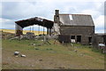
Barn and old farmhouse, Hafod-y-dafal
Half of the farmhouse has been demolished. The iron tank by the house is said to have come from the former Webb's Brewery, Aberbeeg.
Image: © M J Roscoe
Taken: 7 Jun 2020
0.04 miles
2
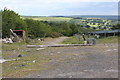
Track by side of solar panels, Hafod-y-dafal
The track leads to a field downhill past two sections of the solar farm. The trees are part of the western edge of The Plantation in Cwm Big. The distant fields next to the mast overlook the Ebbw Fach Valley.
Image: © M J Roscoe
Taken: 7 Jun 2020
0.07 miles
4
Part of Hafod-y-dafal Solar Farm
A section of the large farm on the ridge between the Ebbw and Big valleys.
Image: © M J Roscoe
Taken: 7 Jun 2020
0.14 miles
5
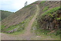
Track up side of Cwm Big
Stony track in Coed Big on bare hillside which appears to have been clear felled, probably of larch.
Image: © M J Roscoe
Taken: 7 Jun 2020
0.14 miles
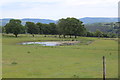
6
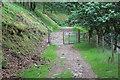
Cattle grid in oak woodland, Cwm Big
Narrow grid and gate (not on current OS map) across forestry track; the right hand railing of the grid has been moved.
Image: © M J Roscoe
Taken: 7 Jun 2020
0.16 miles
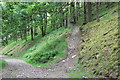
7
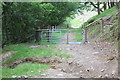
Gate & cattle grid on forest track, Cwm Big
Looking downhill at the grid in Image with oak woodland on the left. A side railing on the narrow grid has been moved; gully in the foreground. The white pole further down the track marks the position of an underground electricity cable.
Image: © M J Roscoe
Taken: 7 Jun 2020
0.16 miles
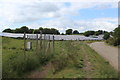
8
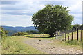
Tree by Hafod-y-dafal Solar Farm enclosure
Tree stands in a gap between the two southernmost sections of the solar farm.
Image: © M J Roscoe
Taken: 7 Jun 2020
0.18 miles
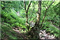
9
Path up through oak woodland, Cwm
Path off forest track into The Plantation, Coed Big.
Image: © M J Roscoe
Taken: 7 Jun 2020
0.18 miles
10
Ash tree by Nant Big, Cwm Big
An old ash tree, that may be suffering from ash dieback, above a dried up stream.
Image: © M J Roscoe
Taken: 13 Jun 2020
0.18 miles