IMAGES TAKEN NEAR TO
Woodland Terrace, ABERTILLERY, NP13 2EN
Introduction
This page details the photographs taken nearby to Woodland Terrace, NP13 2EN by members of the Geograph project.
The Geograph project started in 2005 with the aim of publishing, organising and preserving representative images for every square kilometre of Great Britain, Ireland and the Isle of Man.

There are currently over 7.5m images from over14,400 individuals and you can help contribute to the project by visiting https://www.geograph.org.uk
Image Map
Images are licensed for reuse under creativecommons.org/licenses/by-sa/2.0
Notes
- Clicking on the map will re-center to the selected point.
- The higher the marker number, the further away the image location is from the centre of the postcode.
Image Listing (24 Images Found)
Images are licensed for reuse under creativecommons.org/licenses/by-sa/2.0
Image
Details
Distance
1
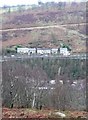
Woodland Terrace
Woodland Terrace from Warmturn
Image: © Pat Addison
Taken: 20 Jul 2008
0.01 miles
2

Ebbw Fach River behind Woodland Terrace, Aberbeeg
Looking upstream from just off the Ebbw Fach Trail.
Image: © M J Roscoe
Taken: 27 Jul 2016
0.02 miles
3

Ebbw Fach Trail behind Woodland Terrace, Aberbeeg
The trail, on the route of a dismantled railway, is heading towards Beaufort. This section is part of National Cycle Route 465.
Image: © M J Roscoe
Taken: 27 Jul 2016
0.03 miles
4
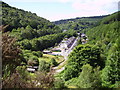
Houses in the valley
Taken from the highest road on the eastern side of the valley of the Ebwy Fach. These houses are on the A467 on the west side of the valley with the steep hillside above Aberbeeg behind. There are more houses closer to the valley floor.
Image: © Graham Horn
Taken: 3 Feb 2008
0.05 miles
7
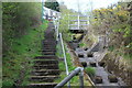
Steps up to Aberbeeg Road from Parc Arael Griffin
Concrete steps on edge of park by drain to river.
Image: © M J Roscoe
Taken: 1 May 2023
0.14 miles
8
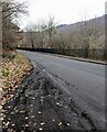
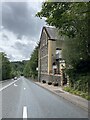
WSW along Victoria Road near Six Bells, Blaenau Gwent
A Six Bells name sign https://www.geograph.org.uk/photo/7404232 is behind the camera. Ahead on Victoria Road for Aberbeeg.
Image: © Jaggery
Taken: 12 Feb 2023
0.15 miles
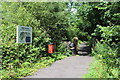
9
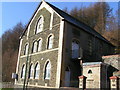
Walker on the Ebbw Fach Trail, Aberbeeg
'Gateway' on combined cycle and pedestrian path by Brewery Court on former railway trackbed.
Image: © M J Roscoe
Taken: 1 May 2023
0.17 miles
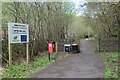
10
Access to Ebbw Fach Trail, Aberbeeg
Access point to the trail in Aberbeeg; the trail is part of National Cycle Route 465
Image: © M J Roscoe
Taken: 27 Jul 2016
0.17 miles