IMAGES TAKEN NEAR TO
Aberbeeg, ABERTILLERY, NP13 2DL
Introduction
This page details the photographs taken nearby to NP13 2DL by members of the Geograph project.
The Geograph project started in 2005 with the aim of publishing, organising and preserving representative images for every square kilometre of Great Britain, Ireland and the Isle of Man.

There are currently over 7.5m images from over14,400 individuals and you can help contribute to the project by visiting https://www.geograph.org.uk
Image Map
Images are licensed for reuse under creativecommons.org/licenses/by-sa/2.0
Notes
- Clicking on the map will re-center to the selected point.
- The higher the marker number, the further away the image location is from the centre of the postcode.
Image Listing (28 Images Found)
Images are licensed for reuse under creativecommons.org/licenses/by-sa/2.0
Image
Details
Distance
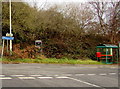
1
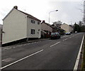
Road from Cwm Nant Gwynt towards Pen-y-fan Country Park
Ahead for Pen-y-fan Country Park or left for Trinant.
Image: © Jaggery
Taken: 9 Dec 2016
0.07 miles
2
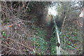
Hillside footpath, Cwm-Nant-Gwynt
Public footpath, part of the Ebbw Valley Walk, heading up the hillside from the road to a stile Image
Image: © M J Roscoe
Taken: 18 Dec 2016
0.08 miles
3
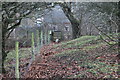
Stile, Ebbw Valley Walk, above Pantddu Road
Field footpath alongside fence leading to stile at the top of an incline Image heading down to the right to the road.
Image: © M J Roscoe
Taken: 16 Dec 2016
0.08 miles
4
Stable, Cwm-nant-gwynt
Solitary stable of metal in paddock above the Nant Gwynt near Pentrapeod.
Image: © M J Roscoe
Taken: 18 Dec 2016
0.08 miles
5
Cwm Nant Gwynt name sign
The small white-on-blue sign on the left, facing the road from Trinant,
contrasts with this http://www.geograph.org.uk/photo/5220627 sign at the northern edge of the hamlet.
Image: © Jaggery
Taken: 9 Dec 2016
0.09 miles
6
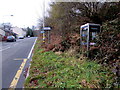
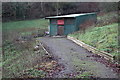
Overgrown BT phonebox, Cwm Nant Gwynt
In December 2016, brambles and ferns are outside and inside
the BT phonebox in the hamlet of Cwm Nant Gwynt, one mile from Trinant.
Image: © Jaggery
Taken: 9 Dec 2016
0.10 miles
7
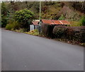
Rusty roofed roadside buildings, Cwm Nant Gwynt
Alongside the road to Trinant.
Image: © Jaggery
Taken: 19 Dec 2016
0.10 miles
8
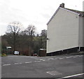
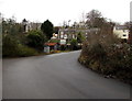
Junction in Cwm Nant Gwynt
In the hamlet of Cwm Nant Gwynt, the road descends towards Trinant, a village in the community of Crumlin.
Image: © Jaggery
Taken: 9 Dec 2016
0.10 miles
9
Bend in the road from Trinant to Cwm Nant Gwynt
Houses in the hamlet of Cwm Nant Gwynt are in the background.
Image: © Jaggery
Taken: 19 Dec 2016
0.10 miles
10
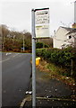
Welsh side of a bilingual bus stop sign, Cwm Nant Gwynt
Located here. http://www.geograph.org.uk/photo/5220955 This side shows Safle Bws, Lle Bute, Coed Duon.
The opposite side http://www.geograph.org.uk/photo/5220958 shows Bus Stop, Bute Place, Blackwood.
Image: © Jaggery
Taken: 9 Dec 2016
0.10 miles