IMAGES TAKEN NEAR TO
Six Bells, ABERTILLERY, NP13 2AZ
Introduction
This page details the photographs taken nearby to NP13 2AZ by members of the Geograph project.
The Geograph project started in 2005 with the aim of publishing, organising and preserving representative images for every square kilometre of Great Britain, Ireland and the Isle of Man.

There are currently over 7.5m images from over14,400 individuals and you can help contribute to the project by visiting https://www.geograph.org.uk
Image Map
Images are licensed for reuse under creativecommons.org/licenses/by-sa/2.0
Notes
- Clicking on the map will re-center to the selected point.
- The higher the marker number, the further away the image location is from the centre of the postcode.
Image Listing (3 Images Found)
Images are licensed for reuse under creativecommons.org/licenses/by-sa/2.0
Image
Details
Distance
1
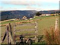
Sticil Gilfach Wen Stile
Sticil ar lwybr cyhoeddus yn mynd i gyfeiriad Cwm Llwydrew a Six Bells. Yr anhedd-dy yn y pellter yw Gilfach Wen.
A stile on a public footpath heading in the direction of Cwm Llwydrew (hoarfrost [stream] valley) and Six Bells. The property in the distance is known as Gifach Wen (trans. fair nook).
Image: © Alan Richards
Taken: 12 Oct 2014
0.12 miles
2
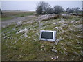
New 2007 Outside broadcasting
This was the last thing that I expected to find in-situ on a Welsh hillside - maybe it's for the sheep to watch Neighbours!
Image: © Nick Mutton 01329 000000
Taken: 15 Dec 2007
0.23 miles
3
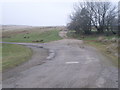
A corner of Welsh hillside
Image: © Nick Mutton 01329 000000
Taken: 15 Dec 2007
0.24 miles