IMAGES TAKEN NEAR TO
Cwrt Bracty, ABERTILLERY, NP13 2AH
Introduction
This page details the photographs taken nearby to Cwrt Bracty, NP13 2AH by members of the Geograph project.
The Geograph project started in 2005 with the aim of publishing, organising and preserving representative images for every square kilometre of Great Britain, Ireland and the Isle of Man.

There are currently over 7.5m images from over14,400 individuals and you can help contribute to the project by visiting https://www.geograph.org.uk
Image Map
Images are licensed for reuse under creativecommons.org/licenses/by-sa/2.0
Notes
- Clicking on the map will re-center to the selected point.
- The higher the marker number, the further away the image location is from the centre of the postcode.
Image Listing (91 Images Found)
Images are licensed for reuse under creativecommons.org/licenses/by-sa/2.0
Image
Details
Distance
1
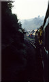
Approaching Aberbeeg
Class 33, 33019 descends the truncated Aberbeeg - Brynmawr line after visiting Rose Heyworth with the Welsh Washery Wanderer railtour. In this photo the train is approaching the closed Aberbeeg station - the platform of which has just come into view around the curve. The buildings in the centre of the photo are Webbs Brewery, by then a distribution centre for the Bass group. The brewery has subsequently been demolished and new housing built in its place on the aptly named Brewery Court. Aberbeeg Church can be seen in the haze on the hillside across the valley. The section of railway line has since closed and is now a cycle route.
Image: © Martin Addison
Taken: 28 Sep 1985
0.02 miles
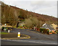
2
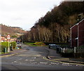
Brewery Court, Aberbeeg
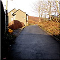
Viewed across the B4471. Brewery Court (Cwrt Bracty in Welsh) is a dead end road extending
ahead for 180 metres along the east bank of the Ebbw Fach River (Afon Ebwy Fach in Welsh).
Image: © Jaggery
Taken: 9 Dec 2016
0.02 miles
3
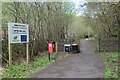
Walker on the Ebbw Fach Trail, Aberbeeg
'Gateway' on combined cycle and pedestrian path by Brewery Court on former railway trackbed.
Image: © M J Roscoe
Taken: 1 May 2023
0.02 miles
4
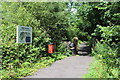
Access to Ebbw Fach Trail, Aberbeeg
Access point to the trail in Aberbeeg; the trail is part of National Cycle Route 465
Image: © M J Roscoe
Taken: 27 Jul 2016
0.02 miles
5
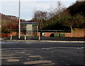
Bus stop and green shelter on an Aberbeeg corner
On the corner of the B4471 and Woodland Terrace. Also in view are a green litter bin and two green flower tubs.
Image: © Jaggery
Taken: 9 Dec 2016
0.05 miles
6
Woodland Terrace, Aberbeeg
On the north side of the B4471.
Image: © Jaggery
Taken: 9 Dec 2016
0.05 miles
7
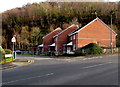
Row of three brick houses on an Aberbeeg corner
On the corner of the B4471 and Brewery Court.
Image: © Jaggery
Taken: 9 Dec 2016
0.05 miles
8
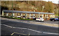
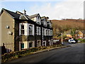
Brewery Terrace, Aberbeeg
Viewed across the B4471. Extending for 40 metres (about 130 ft), the row was built opposite Webbs Brewery, which no longer exists. The brewery, dating from 1838, closed in 1969.
Image: © Jaggery
Taken: 9 Dec 2016
0.06 miles
9
Up Railway Terrace, Aberbeeg
Railway Terrace ascends towards the B4471 from this http://www.geograph.org.uk/photo/5222023 railway bridge.
Image: © Jaggery
Taken: 9 Dec 2016
0.06 miles
10
Railway Terrace houses, Aberbeeg
The B4471 junction is ahead.
Image: © Jaggery
Taken: 9 Dec 2016
0.06 miles