IMAGES TAKEN NEAR TO
Railway Terrace, ABERTILLERY, NP13 2AD
Introduction
This page details the photographs taken nearby to Railway Terrace, NP13 2AD by members of the Geograph project.
The Geograph project started in 2005 with the aim of publishing, organising and preserving representative images for every square kilometre of Great Britain, Ireland and the Isle of Man.

There are currently over 7.5m images from over14,400 individuals and you can help contribute to the project by visiting https://www.geograph.org.uk
Image Map (Loading...)


Getting Data...Please wait
Leaflet Map data © OpenStreetMap
Images are licensed for reuse under creativecommons.org/licenses/by-sa/2.0
Notes
- Clicking on the map will re-center to the selected point.
- The higher the marker number, the further away the image location is from the centre of the postcode.
Image Listing (116 Images Found)
Images are licensed for reuse under creativecommons.org/licenses/by-sa/2.0
Image
Details
Distance
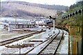
1
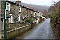
Railway Terrace, Aberbeeg
The houses are close to the embankment (right) of the railway to Ebbw Vale. The parapet of the railway bridge can be discerned through the drizzle at the end of the road.
Image: © M J Roscoe
Taken: 26 Nov 2015
0.01 miles
2
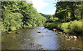
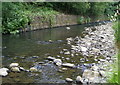
Ebbw River, Railway Terrace, Aberbeeg
Looking upstream from the middle of the river bed, water level at its lowest. This once-polluted river now supports salmonids and otters The rear gardens of Railway Terrace on the right of the picture.
Image: © M J Roscoe
Taken: 30 Jul 2015
0.02 miles
4
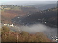
Railway Terrace & River Ebbw, Aberbeeg
Railway Terrace is sandwiched between the river and the site of the former railway sidings. To the right, the trees on the bank have been felled to allow the gabions below them to be repaired Image
Image: © M J Roscoe
Taken: 28 Apr 2016
0.05 miles
5
Near Aberbeeg railway station (site), Gwent, 1984
Taken from a freight train descending from Ebbw Vale steelworks. At the time, there was no passenger train service to Ebbw Vale.
Image: © Nigel Thompson
Taken: 8 Mar 1984
0.05 miles
6
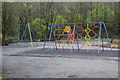
Playground, Aberbeeg
Children's playground near Aberbeeg Community Centre and new cycle lane. The bushes to the right of the playground have been removed recently.
Image: © M J Roscoe
Taken: 30 Mar 2017
0.05 miles
7
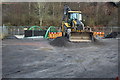
Construction yard for cycle bridge, Aberbeeg
Construction yard on west bank of the River Ebbw on a Sunday.
Image: © M J Roscoe
Taken: 18 Dec 2016
0.06 miles
8
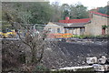
Bridge construction work, River Ebbw, Aberbeeg, October
The steel rods on top of the bank appear to be the support for the cycle bridge that is to built here across the river. The rectangular concrete pillar (left) next to the damaged bush is the remains of a support for the footbridge which was here in the past.
Image: © M J Roscoe
Taken: 27 Oct 2016
0.06 miles
9
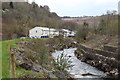
Ebbw River, near Railway Terrace, Aberbeeg, Summer
Looking upstream from behind Aberbeeg RFC Clubhouse; river viewed from a different angle to downstream view in Image
Image: © M J Roscoe
Taken: 25 Jun 2010
0.07 miles
10
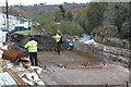
Construction of bridge pier, Aberbeeg, October
Assembling reinforcing rods for pier/plinth for cycle bridge over the River Ebbw at Railway Terrace (houses in left background).
Image: © M J Roscoe
Taken: 27 Oct 2016
0.07 miles