IMAGES TAKEN NEAR TO
Carlyle Street, ABERTILLERY, NP13 1UF
Introduction
This page details the photographs taken nearby to Carlyle Street, NP13 1UF by members of the Geograph project.
The Geograph project started in 2005 with the aim of publishing, organising and preserving representative images for every square kilometre of Great Britain, Ireland and the Isle of Man.

There are currently over 7.5m images from over14,400 individuals and you can help contribute to the project by visiting https://www.geograph.org.uk
Image Map
Images are licensed for reuse under creativecommons.org/licenses/by-sa/2.0
Notes
- Clicking on the map will re-center to the selected point.
- The higher the marker number, the further away the image location is from the centre of the postcode.
Image Listing (92 Images Found)
Images are licensed for reuse under creativecommons.org/licenses/by-sa/2.0
Image
Details
Distance
1
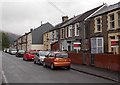
Carlyle Street houses, Abertillery
Looking NW towards Glandwr Street.
Image: © Jaggery
Taken: 14 Jun 2013
0.01 miles
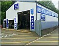
2
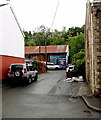
Abertillery Auto Centre
Set back 30 metres from Carlyle Street Abertillery.
Image: © Jaggery
Taken: 14 Jun 2013
0.01 miles
3
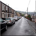
Cars in Carlyle Street, Abertillery
A view SE from the turning for Abertillery Auto Centre. http://www.geograph.org.uk/photo/3510670
Image: © Jaggery
Taken: 14 Jun 2013
0.07 miles
4
Glandwr Street pumping station, Abertillery
The brick pumping station with a faded pink door is a Welsh Water asset located between Glandwr Street and a river, the Ebbw Fach.
Image: © Jaggery
Taken: 14 Jun 2013
0.09 miles
5
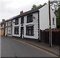
Conspicuous house at the SE end of Carlyle Street, Abertillery
The house differs from adjacent houses in its distinctive white and black colour.
A tablet above the door shows PRESWYLFA 1900. Preswylfa is Welsh for residence or dwelling-place.
Image: © Jaggery
Taken: 14 Jun 2013
0.09 miles
6
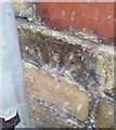
Ordnance Survey Cut Mark
The remains of this OS cut mark can be found on the wall of No62 Oak Street. It marked a point 220.209m above mean sea level.
Image: © Adrian Dust
Taken: 20 Jan 2018
0.10 miles
7
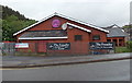
SE end of The Foundry, Abertillery
The Foundry pub and restaurant is on the corner of Bridge Street and Carlyle Street.
The premises were formerly occupied by Lymes Social Club.
Image: © Jaggery
Taken: 14 Jun 2013
0.11 miles
8
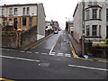
Clynmawr Street, Abertillery
Clynmawr Street climbs away from Oak Street towards Gladstone Street.
Image: © Jaggery
Taken: 14 Jun 2013
0.11 miles
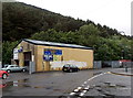
9
Abertillery Mot Centre
Abertillery Mot Centre - Class 4 and 7, motorhomes, campervans, tyres, servicing and repairs.
Image: © Lewis Clark
Taken: 4 Jul 2021
0.11 miles
10
Abertillery MoT Centre
Located in Bridge Street next door to The Railway Inn. http://www.geograph.org.uk/photo/3509990 In the UK, the MoT test is mandatory annually for vehicles 3 years old and older. (1 year old in some cases). The test checks that a vehicle meets road safety and environmental standards.
Image: © Jaggery
Taken: 14 Jun 2013
0.11 miles