IMAGES TAKEN NEAR TO
Attlee Avenue, ABERTILLERY, NP13 1SW
Introduction
This page details the photographs taken nearby to Attlee Avenue, NP13 1SW by members of the Geograph project.
The Geograph project started in 2005 with the aim of publishing, organising and preserving representative images for every square kilometre of Great Britain, Ireland and the Isle of Man.

There are currently over 7.5m images from over14,400 individuals and you can help contribute to the project by visiting https://www.geograph.org.uk
Image Map
Images are licensed for reuse under creativecommons.org/licenses/by-sa/2.0
Notes
- Clicking on the map will re-center to the selected point.
- The higher the marker number, the further away the image location is from the centre of the postcode.
Image Listing (4 Images Found)
Images are licensed for reuse under creativecommons.org/licenses/by-sa/2.0
Image
Details
Distance
3
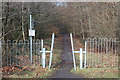
Ebbw Fach Trail, near Roseheyworth, Abertillery
Cycle/footpath going north from the end of Abertillery Park, part of National Cycle Route 465.
Image: © M J Roscoe
Taken: 16 Feb 2018
0.23 miles
4
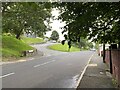
Road junction
Junction of Smith Road and Rose Hayworth Road.
Image: © Alan Hughes
Taken: 9 Aug 2021
0.23 miles