IMAGES TAKEN NEAR TO
Arael View, ABERTILLERY, NP13 1SS
Introduction
This page details the photographs taken nearby to Arael View, NP13 1SS by members of the Geograph project.
The Geograph project started in 2005 with the aim of publishing, organising and preserving representative images for every square kilometre of Great Britain, Ireland and the Isle of Man.

There are currently over 7.5m images from over14,400 individuals and you can help contribute to the project by visiting https://www.geograph.org.uk
Image Map
Images are licensed for reuse under creativecommons.org/licenses/by-sa/2.0
Notes
- Clicking on the map will re-center to the selected point.
- The higher the marker number, the further away the image location is from the centre of the postcode.
Image Listing (16 Images Found)
Images are licensed for reuse under creativecommons.org/licenses/by-sa/2.0
Image
Details
Distance
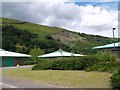
1
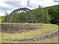
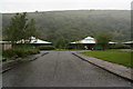
The Site of Roseheyworth Colliery
Now a business park.
Image: © Chris Andrews
Taken: 7 Jun 2017
0.10 miles
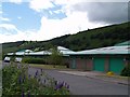
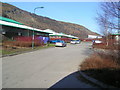
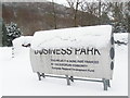
4
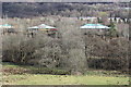
Roseheyworth Business Park, Abertillery
Roofs of pagoda-like Park buildings viewed from Old Blaina Road. At the bottom of the field are the young trees lining the Ebbw Fach River, and the Ebbw Fach Trail can just be seen through the trees.
Image: © M J Roscoe
Taken: 16 Feb 2018
0.13 miles