IMAGES TAKEN NEAR TO
Preston Street, ABERTILLERY, NP13 1QL
Introduction
This page details the photographs taken nearby to Preston Street, NP13 1QL by members of the Geograph project.
The Geograph project started in 2005 with the aim of publishing, organising and preserving representative images for every square kilometre of Great Britain, Ireland and the Isle of Man.

There are currently over 7.5m images from over14,400 individuals and you can help contribute to the project by visiting https://www.geograph.org.uk
Image Map
Images are licensed for reuse under creativecommons.org/licenses/by-sa/2.0
Notes
- Clicking on the map will re-center to the selected point.
- The higher the marker number, the further away the image location is from the centre of the postcode.
Image Listing (79 Images Found)
Images are licensed for reuse under creativecommons.org/licenses/by-sa/2.0
Image
Details
Distance
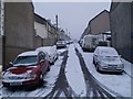
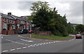
2
Preston Street, Blaenau Gwent
Viewed from Alma Street, Cwmtillery. On the right is the cemetery boundary wall of
Blaenau Gwent Baptist Church, Victoria Street.
Image: © Jaggery
Taken: 24 Jun 2013
0.02 miles
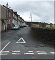
3
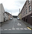
Oxford Street, Cwmtillery
Oxford Street climbs away from Alma Street.
Here's http://www.geograph.org.uk/photo/1158857 a snowy view of the street.
Image: © Jaggery
Taken: 24 Jun 2013
0.03 miles
4
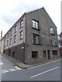
Former Brynteg Congregational Church, Cwmtillery
Located on the corner of Oxford Street and Alma Street, Brynteg House contains 6 flats.
An inscription on the Alma Street side shows
BRYNTEG CONGREGATIONAL CHURCH
CHAPEL BUILT AD 1914.
Image: © Jaggery
Taken: 24 Jun 2013
0.04 miles
5
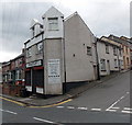
Perfect Image, Cwmtillery
Unisex hair & beauty salon on the corner of Oxford Street and Alma Street.
Image: © Jaggery
Taken: 24 Jun 2013
0.04 miles
6
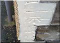
Ordnance Survey Cut Mark
This OS cut mark can be found on No61 Clyn Mawr Street. It marks a point 253.051m above mean sea level.
Image: © Adrian Dust
Taken: 20 Jan 2018
0.04 miles
7
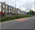
Row of houses, Alma Street, Abertillery
Viewed across Alma Street looking towards the southern boundary of Cwmtillery.
Image: © Jaggery
Taken: 24 Jun 2013
0.05 miles
8
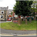
Standing stones at the village boundary, Cwmtillery
The stones are at the southern boundary http://www.geograph.org.uk/photo/3526596 of Cwmtillery (and the northern boundary of Abertillery).
Image: © Jaggery
Taken: 24 Jun 2013
0.06 miles
9
Southern boundary sign, Cwmtillery
Alma Street Abertillery becomes Alma Street Cwmtillery ahead on the left.
Image: © Jaggery
Taken: 24 Jun 2013
0.06 miles
10
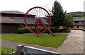
Former colliery winding wheel outside Abertillery Comprehensive School
Located at the southern edge of the school.
Image: © Jaggery
Taken: 24 Jun 2013
0.07 miles