IMAGES TAKEN NEAR TO
Gwastod Farm, ABERTILLERY, NP13 1NS
Introduction
This page details the photographs taken nearby to Gwastod Farm, NP13 1NS by members of the Geograph project.
The Geograph project started in 2005 with the aim of publishing, organising and preserving representative images for every square kilometre of Great Britain, Ireland and the Isle of Man.

There are currently over 7.5m images from over14,400 individuals and you can help contribute to the project by visiting https://www.geograph.org.uk
Image Map
Images are licensed for reuse under creativecommons.org/licenses/by-sa/2.0
Notes
- Clicking on the map will re-center to the selected point.
- The higher the marker number, the further away the image location is from the centre of the postcode.
Image Listing (62 Images Found)
Images are licensed for reuse under creativecommons.org/licenses/by-sa/2.0
Image
Details
Distance
1
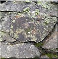
Ordnance Survey Cut Mark
This OS cut mark can be found on the wall of St Paul's Church. It marks a point 319.522m above mean sea level.
Image: © Adrian Dust
Taken: 16 Feb 2024
0.05 miles
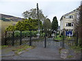
2
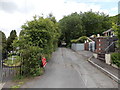
Road from gate to lych gate, Cwmtillery
Viewed from this http://www.geograph.org.uk/photo/3211325 gate looking up the road towards this http://www.geograph.org.uk/photo/3529051 gate.
Image: © Jaggery
Taken: 24 Jun 2013
0.05 miles
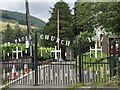
3
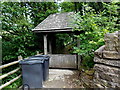
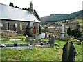
Lych gate, St Paul's church, Cwmtillery
This entrance is in the SE corner of the churchyard which is located on steeply sloping ground above Cwmtillery Lakes.
Image: © Jaggery
Taken: 24 Jun 2013
0.05 miles
4
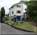
Vicarage, St Paul's church, Cwmtillery
Located in the southern corner of the churchyard.
Image: © Jaggery
Taken: 24 Jun 2013
0.05 miles
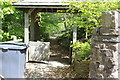
5
Access driveway to St. Paul's church, Cwmtillery
Access for the large graveyard I believe.
Image: © Jeremy Bolwell
Taken: 4 Nov 2012
0.05 miles
7
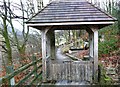
St. Paul's, Cwm Tyleri
This is the eastern lych gate entrance to the churchyard. It is still very much an active church, with many very new graves on the steep hillside. It is also an important wildlife site and has an active preservation group.
Image: © Graham Horn
Taken: 2 Feb 2008
0.06 miles
8
Lych gate, St Paul's Churchyard, Cwmtillery
Entrance from Church Lane to graveyard on steep hillside.
Image: © M J Roscoe
Taken: 15 May 2019
0.06 miles
9
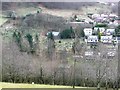
St . Paul's, Cwm Tyleri
Seen from across the valley, the church of St. Paul's lies at the top end of the village with an extensive churchyard. Between the quarter chimes the bells play a medley of tunes, that do not appear to be all Welsh. The sound travelled a long way up the valley and I'm sure I heard Danny Boy and Flower of Scotland. Maybe they were anticipating the famous Welsh win at Twickenham later that day.
Image: © Graham Horn
Taken: 2 Feb 2008
0.06 miles
10
St. Paul's, Cwm Tyleri
An attractive setting overlooking the valley of the same name.
Image: © Graham Horn
Taken: 2 Feb 2008
0.07 miles