IMAGES TAKEN NEAR TO
Granville Street, ABERTILLERY, NP13 1NR
Introduction
This page details the photographs taken nearby to Granville Street, NP13 1NR by members of the Geograph project.
The Geograph project started in 2005 with the aim of publishing, organising and preserving representative images for every square kilometre of Great Britain, Ireland and the Isle of Man.

There are currently over 7.5m images from over14,400 individuals and you can help contribute to the project by visiting https://www.geograph.org.uk
Image Map
Images are licensed for reuse under creativecommons.org/licenses/by-sa/2.0
Notes
- Clicking on the map will re-center to the selected point.
- The higher the marker number, the further away the image location is from the centre of the postcode.
Image Listing (54 Images Found)
Images are licensed for reuse under creativecommons.org/licenses/by-sa/2.0
Image
Details
Distance
1
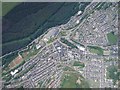
Abertillery from a Paraglider
Photo taken from 2000ft above during a fantastic weekend's flying in August 2005. Take off was from The Blorenge in Image
Image: © Graham Richards
Taken: Unknown
0.05 miles
2
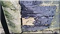
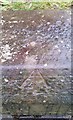
Ordnance Survey Cut Mark
This OS cut mark can be found on No16 Springbank. It marks a point 260.891m above mean sea level.
Image: © Adrian Dust
Taken: 20 Jan 2018
0.05 miles
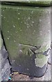
3
Ordnance Survey Cut Mark
This OS cut mark can be found on No41 Nuadd Street. It marks a point 246.833m above mean sea level.
Image: © Adrian Dust
Taken: 20 Jan 2018
0.07 miles
4
Ordnance Survey Cut Mark
This OS cut mark can be found on The Crown Inn, Victoria Street. It marks a point 273.765m above mean sea level.
Image: © Adrian Dust
Taken: 20 Jan 2018
0.08 miles
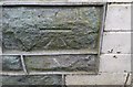
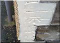
5
Ordnance Survey Rivet
This OS rivet can be found on the old school, Crown Street. It marks a point 271.287m above mean sea level.
Image: © Adrian Dust
Taken: 20 Jan 2018
0.08 miles
6
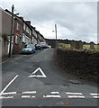
Preston Street, Blaenau Gwent
Viewed from Alma Street, Cwmtillery. On the right is the cemetery boundary wall of
Blaenau Gwent Baptist Church, Victoria Street.
Image: © Jaggery
Taken: 24 Jun 2013
0.08 miles
7
Ordnance Survey Cut Mark
This OS cut mark can be found on No61 Clyn Mawr Street. It marks a point 253.051m above mean sea level.
Image: © Adrian Dust
Taken: 20 Jan 2018
0.08 miles
8
Oxford Street, Cwmtillery
Oxford Street climbs away from Alma Street.
Here's http://www.geograph.org.uk/photo/1158857 a snowy view of the street.
Image: © Jaggery
Taken: 24 Jun 2013
0.09 miles
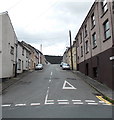
9
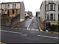
Clynmawr Street, Abertillery
Clynmawr Street climbs away from Oak Street towards Gladstone Street.
Image: © Jaggery
Taken: 14 Jun 2013
0.10 miles
10
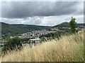
A valleys town
View over Abertillery from the slopes of Penrhiwgarreg.
Image: © Alan Hughes
Taken: 9 Aug 2021
0.11 miles