IMAGES TAKEN NEAR TO
Tyleri Gardens, Victor Road, ABERTILLERY, NP13 1EZ
Introduction
This page details the photographs taken nearby to Tyleri Gardens, Victor Road, NP13 1EZ by members of the Geograph project.
The Geograph project started in 2005 with the aim of publishing, organising and preserving representative images for every square kilometre of Great Britain, Ireland and the Isle of Man.

There are currently over 7.5m images from over14,400 individuals and you can help contribute to the project by visiting https://www.geograph.org.uk
Image Map
Images are licensed for reuse under creativecommons.org/licenses/by-sa/2.0
Notes
- Clicking on the map will re-center to the selected point.
- The higher the marker number, the further away the image location is from the centre of the postcode.
Image Listing (46 Images Found)
Images are licensed for reuse under creativecommons.org/licenses/by-sa/2.0
Image
Details
Distance
1
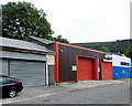
Victor Road premises to let, Abertillery
Below the estate agents' To Let board is the name of the previous occupier of the premises :
Mike's Auto Service Centre.
Image: © Jaggery
Taken: 24 Jun 2013
0.02 miles
2
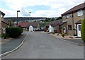
Tyleri Gardens, Abertillery
Tyleri Gardens is a residential cul-de-sac on the south side of Victor Road.
Image: © Jaggery
Taken: 24 Jun 2013
0.02 miles
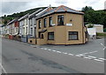
3
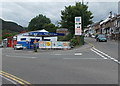
Penybont Service Station, Abertillery
Located on the corner of Victor Road and Tillery Road. A sign shows hand car wash and shop.
Image: © Jaggery
Taken: 24 Jun 2013
0.03 miles
4
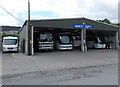
Henleys bus and coach depot, Abertillery
Viewed across Victor Road. Henleys provide coach tours and operate several bus routes in the Abertillery area.
Image: © Jaggery
Taken: 24 Jun 2013
0.05 miles
5
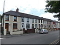
Tillery Road houses south of Cefn Crescent, Abertillery
Looking along Tillery Road towards the Duffryn Road junction.
Image: © Jaggery
Taken: 24 Jun 2013
0.05 miles
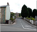
6
Corner of Tillery Road and Duffryn Road, Abertillery
Duffryn Road on the right is the point where Tillery Road to the north (ahead) becomes Tillery Street to the south.
Image: © Jaggery
Taken: 24 Jun 2013
0.06 miles
7
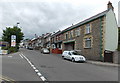
Tillery Road, Abertillery
Tillery Road heads north away from Abertillery towards Cwmtillery.
On the left is Victor Road and Penybont Service Station. http://www.geograph.org.uk/photo/3535602
Image: © Jaggery
Taken: 24 Jun 2013
0.06 miles
8
Cefn Crescent, Abertillery
Cefn Crescent climbs away from Tillery Road.
Image: © Jaggery
Taken: 24 Jun 2013
0.06 miles
9
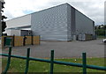
Abertillery Leisure Centre
This is the NE corner of Abertillery Leisure Centre, located on the north side of Abertillery Comprehensive School. Viewed from Tillery Road.
Image: © Jaggery
Taken: 24 Jun 2013
0.06 miles
10
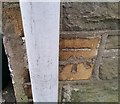
Ordnance Survey Cut Mark
This OS cut mark can be found on No125 Tillery Street. It marks a point 244.818m above mean sea level.
Image: © Adrian Dust
Taken: 20 Jan 2018
0.07 miles