IMAGES TAKEN NEAR TO
Park Place, ABERTILLERY, NP13 1ED
Introduction
This page details the photographs taken nearby to Park Place, NP13 1ED by members of the Geograph project.
The Geograph project started in 2005 with the aim of publishing, organising and preserving representative images for every square kilometre of Great Britain, Ireland and the Isle of Man.

There are currently over 7.5m images from over14,400 individuals and you can help contribute to the project by visiting https://www.geograph.org.uk
Image Map
Images are licensed for reuse under creativecommons.org/licenses/by-sa/2.0
Notes
- Clicking on the map will re-center to the selected point.
- The higher the marker number, the further away the image location is from the centre of the postcode.
Image Listing (160 Images Found)
Images are licensed for reuse under creativecommons.org/licenses/by-sa/2.0
Image
Details
Distance
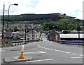
1
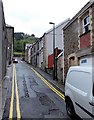
Narrow section of Park Place, Abertillery
Viewed from Church Street.
In Abertillery, as in the rest of the UK, a double yellow line indicates that parking is not permitted at any time (24 hours). Loading or unloading is allowed on double (and single) yellow lines.
Perhaps the drivers of both the vehicles seen here were out of sight in buildings during a loading or unloading session for the few seconds before and after this view was taken...
Image: © Jaggery
Taken: 14 Jun 2013
0.01 miles
2
Park Place viewed from Division Street, Abertillery
Ebenezer Baptist Church is partly in view, from the centre to the left.
Image: © Jaggery
Taken: 5 Mar 2014
0.01 miles
3
Division Street houses, Abertillery
Houses on the south side of Division Street viewed from the corner of Tillery Street looking towards Park Place.
Image: © Jaggery
Taken: 24 Jun 2013
0.03 miles
4
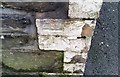
Ordnance Survey Cut Mark
This OS cut mark can be found on the wall of No67 Powell Street. It marks a point 231.864m above mean sea level.
Image: © Adrian Dust
Taken: 20 Jan 2018
0.04 miles
5
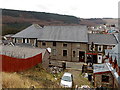
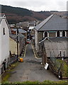
Foundry Bridge, Abertillery
Viewed from Alma Street along the street named Foundry Bridge towards Division Street.
Image: © Jaggery
Taken: 24 Jun 2013
0.04 miles
6
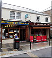
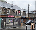
Two Church Street shops, Abertillery
Church Street Fish Bar on the left is at 22 Church Street.
The Coffee Bean on the right is on the corner of Park Place.
Image: © Jaggery
Taken: 14 Jun 2013
0.04 miles
7
Salvation Army charity shop in Abertillery
The town centre shop is at 20 Church Street.
Image: © Jaggery
Taken: 5 Mar 2014
0.04 miles
8
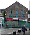
Fenced-off corner of Church Street and Division Street, Abertillery
The derelict shops occupy part of a former church. The inscription on the building is
TRINITY PRESBYTERIAN CHURCH OF WALES
BUILT 1878 REBUILT 1905.
Image: © Jaggery
Taken: 14 Jun 2013
0.04 miles
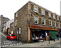
9
Church Street shops, Abertillery
Among the shops in view on the east side of Church Street is Hector's Cozy Cafe & Chippy.
Image: © Jaggery
Taken: 14 Jun 2013
0.04 miles
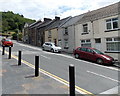
10
Towards Church Street from Division Street Abertillery
The narrow road passes Ebenezer Baptist Church, the building to the right of double yellow lines.
Image: © Jaggery
Taken: 5 Mar 2014
0.05 miles