IMAGES TAKEN NEAR TO
Castle Street, ABERTILLERY, NP13 1DT
Introduction
This page details the photographs taken nearby to Castle Street, NP13 1DT by members of the Geograph project.
The Geograph project started in 2005 with the aim of publishing, organising and preserving representative images for every square kilometre of Great Britain, Ireland and the Isle of Man.

There are currently over 7.5m images from over14,400 individuals and you can help contribute to the project by visiting https://www.geograph.org.uk
Image Map
Images are licensed for reuse under creativecommons.org/licenses/by-sa/2.0
Notes
- Clicking on the map will re-center to the selected point.
- The higher the marker number, the further away the image location is from the centre of the postcode.
Image Listing (178 Images Found)
Images are licensed for reuse under creativecommons.org/licenses/by-sa/2.0
Image
Details
Distance
1
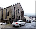
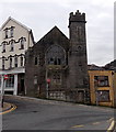
Tabernacle Congregational Church, Abertillery
Town centre church located in Chapel Street. At the June 2013 date of this view, the church was one of 35 churches in Wales affiliated to the Congregational Federation.
Image: © Jaggery
Taken: 14 Jun 2013
0.01 miles
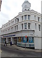
2
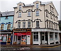
Lloyds TSB Abertillery
Bank branch on the corner of Somerset Street and King Street.
A one-way system, with double yellow lines (indicating no parking at any time) on both sides of the street, operates in several of the narrow streets in this part of central Abertillery.
Image: © Jaggery
Taken: 16 Feb 2011
0.01 miles
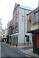
3
The Commercial Hotel, Abertillery
The dark brown building in the middle is The Commercial Hotel pub, Market Street, viewed from the corner of King Street. Small casks or kegs are embedded in the building between the first floor windows.
Image: © Jaggery
Taken: 16 Feb 2011
0.01 miles
4
Chillies, Abertillery
Indian restaurant and takeaway located on the corner of Mitre Street and King Street. The building was formerly The Mitre Inn.
Image: © Jaggery
Taken: 16 Feb 2011
0.01 miles
5
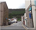
King Street, Abertillery
Viewed from near the Lloyds TSB bank http://www.geograph.org.uk/photo/2293080 in Somerset Street looking towards Castle Street.
Image: © Jaggery
Taken: 24 Jun 2013
0.03 miles
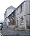
6
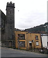
Derelict former Blaenau Gwent RFC club in Abertillery
The derelict High Street building is next door to the derelict former Carmel Chapel. http://www.geograph.org.uk/photo/3874191
Image: © Jaggery
Taken: 5 Mar 2014
0.03 miles
7
Long derelict former Carmel Chapel in Abertillery
Viewed across High Street in March 2014. The building is near the corner of Commercial Street and Carmel Street.
Image: © Jaggery
Taken: 5 Mar 2014
0.04 miles
8
Kelly's Hair Salon, Abertillery
Town centre business on the corner of Carmel Street and Commercial Street.
Image: © Jaggery
Taken: 14 Jun 2013
0.04 miles
9
The Original Factory Shop in Abertillery
In Somerset Street premises formerly occupied by a Somerfield supermarket.
Image: © Jaggery
Taken: 5 Mar 2014
0.04 miles
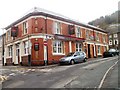
10
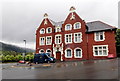
Bush Hotel, Abertillery
The Victory Outreach UK Hostel in the former Bush Hotel provides 24-hour supported accommodation to people aged 18-40 who are on a rehabilitation programme.
Image: © Jaggery
Taken: 14 Jun 2013
0.04 miles