IMAGES TAKEN NEAR TO
The Willows, ABERTILLERY, NP13 1BT
Introduction
This page details the photographs taken nearby to The Willows, NP13 1BT by members of the Geograph project.
The Geograph project started in 2005 with the aim of publishing, organising and preserving representative images for every square kilometre of Great Britain, Ireland and the Isle of Man.

There are currently over 7.5m images from over14,400 individuals and you can help contribute to the project by visiting https://www.geograph.org.uk
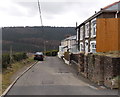
Image Map
Images are licensed for reuse under creativecommons.org/licenses/by-sa/2.0
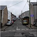
Notes
- Clicking on the map will re-center to the selected point.
- The higher the marker number, the further away the image location is from the centre of the postcode.
Image Listing (133 Images Found)
Images are licensed for reuse under creativecommons.org/licenses/by-sa/2.0
Image
Details
Distance
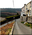
1
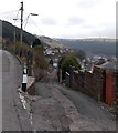
Lane towards Old Barn Way, Abertillery
The lane descends from Pant-y-pwdyn Road.
Image: © Jaggery
Taken: 5 Mar 2014
0.05 miles
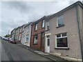
2
Pant-y-pwdyn Road houses, Abertillery
Viewed from the corner of this http://www.geograph.org.uk/photo/4002488 lane.
Image: © Jaggery
Taken: 5 Mar 2014
0.05 miles
3
Up Cwm Farm Road towards Pant-y-pwdyn Road, Abertillery
The houses are in Pant-y-pwdyn Road.
Image: © Jaggery
Taken: 5 Mar 2014
0.05 miles
4
Semis at the far end of Heol Gerrig, Abertillery
Located at the top end of Heol Gerrig. http://www.geograph.org.uk/photo/2293624
Image: © Jaggery
Taken: 16 Feb 2011
0.06 miles
5
Duke Street, Abertillery
Viewed across Cwm Cottage Road.
Image: © Jaggery
Taken: 5 Mar 2014
0.06 miles
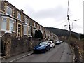
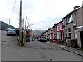
6
Darran Road
A typical street in the Welsh valleys.
Image: © Alan Hughes
Taken: 9 Aug 2021
0.06 miles
7
NW end of Duke Street, Abertillery
Looking along Duke Street from the Pant-y-pwdyn Road junction.
Image: © Jaggery
Taken: 5 Mar 2014
0.06 miles
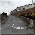
8
Give way ahead, Pant-y-pwdyn Road, Abertillery
Pant-y-pwdyn Road descends towards a triangular sign showing GIVE WAY at the Cwm Farm Road junction.
Image: © Jaggery
Taken: 5 Mar 2014
0.07 miles
9
Pant-y-pwdyn Road, Abertillery
Looking towards the Cwm Farm Road junction.
Image: © Jaggery
Taken: 5 Mar 2014
0.07 miles
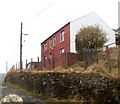
10
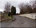
No through road, Penrhiwgarreg, Abertillery
Signs on the wall show 9-12 Penrhiwgarreg and No Through Road.
At about 280 metres (c920 ft) above sea level, this is one of the highest residential areas of Abertillery.
Image: © Jaggery
Taken: 5 Mar 2014
0.07 miles