IMAGES TAKEN NEAR TO
ABERTILLERY, NP13 1BH
Introduction
This page details the photographs taken nearby to NP13 1BH by members of the Geograph project.
The Geograph project started in 2005 with the aim of publishing, organising and preserving representative images for every square kilometre of Great Britain, Ireland and the Isle of Man.

There are currently over 7.5m images from over14,400 individuals and you can help contribute to the project by visiting https://www.geograph.org.uk
Image Map
Images are licensed for reuse under creativecommons.org/licenses/by-sa/2.0
Notes
- Clicking on the map will re-center to the selected point.
- The higher the marker number, the further away the image location is from the centre of the postcode.
Image Listing (66 Images Found)
Images are licensed for reuse under creativecommons.org/licenses/by-sa/2.0
Image
Details
Distance
1
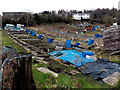
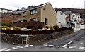
Western edge of Pant-y-Pwdyn Road allotments in Abertillery
Located in Penrhiwgarreg, one of the highest residential areas in Abertillery.
The land here is about 280 metres (more than 900 ft) above mean sea level.
Image: © Jaggery
Taken: 5 Mar 2014
0.03 miles
2
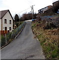
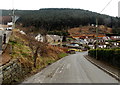
Up towards Penrhiwgarreg, Abertillery
The road ascends from Cwm Farm Lane towards Penrhiwgarreg. http://www.geograph.org.uk/photo/4002405
Image: © Jaggery
Taken: 5 Mar 2014
0.03 miles
3
No through road, Penrhiwgarreg, Abertillery
Signs on the wall show 9-12 Penrhiwgarreg and No Through Road.
At about 280 metres (c920 ft) above sea level, this is one of the highest residential areas of Abertillery.
Image: © Jaggery
Taken: 5 Mar 2014
0.04 miles
4
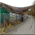
Jogging along Cwm Farm Lane, Abertillery
The jogger passes an allotments perimeter fence in Penrhiwgarreg, an upland area of Abertillery.
Image: © Jaggery
Taken: 5 Mar 2014
0.06 miles
5
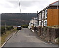
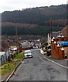
Cwm Farm Lane houses, Abertillery
Viewed from the corner of Cwm Farm Road.
Image: © Jaggery
Taken: 5 Mar 2014
0.07 miles
6
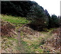
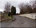
Hillside track, Penrhiwgarreg, Abertillery
The track heads south away from Cwm Farm Lane.
Image: © Jaggery
Taken: 5 Mar 2014
0.07 miles
7
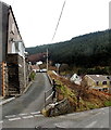
Junction of Cwm Farm Road and Pant-y-pwdyn Road, Abertillery
Cwm Farm Road http://www.geograph.org.uk/photo/4002460 is on the right.
Image: © Jaggery
Taken: 5 Mar 2014
0.07 miles
8
Pant-y-pwdyn Road, Abertillery
Looking towards the Cwm Farm Road junction.
Image: © Jaggery
Taken: 5 Mar 2014
0.09 miles
9
Cwm Farm Road, Abertillery
Looking ESE from the Pant-y-pwdyn Road junction.
Image: © Jaggery
Taken: 5 Mar 2014
0.09 miles
10
Hillside view from Cwm Farm Lane, Abertillery
Viewed from one hillside looking towards another one.
Image: © Jaggery
Taken: 5 Mar 2014
0.10 miles