IMAGES TAKEN NEAR TO
Cwmtillery, ABERTILLERY, NP13 1AQ
Introduction
This page details the photographs taken nearby to NP13 1AQ by members of the Geograph project.
The Geograph project started in 2005 with the aim of publishing, organising and preserving representative images for every square kilometre of Great Britain, Ireland and the Isle of Man.

There are currently over 7.5m images from over14,400 individuals and you can help contribute to the project by visiting https://www.geograph.org.uk
Image Map
Images are licensed for reuse under creativecommons.org/licenses/by-sa/2.0
Notes
- Clicking on the map will re-center to the selected point.
- The higher the marker number, the further away the image location is from the centre of the postcode.
Image Listing (15 Images Found)
Images are licensed for reuse under creativecommons.org/licenses/by-sa/2.0
Image
Details
Distance
1
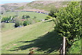
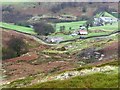
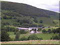
View towards Gwrhyd, Cwm Tyleri
Pastoral scene on the east side of the valley. Gwrhyd farm house is among trees, centre left Image The flank of Mynydd Coety is in the background.
Image: © M J Roscoe
Taken: 15 May 2019
0.05 miles
2
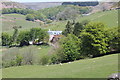
Gwrhyd, Cwm Tyleri
Farm in the valley; the head of the valley is beyond.
Image: © M J Roscoe
Taken: 15 May 2019
0.07 miles
3
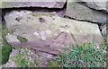
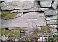
Ordnance Survey Rivet
This OS rivet can be found at the base of the wall NW side of the road. It marks a point 377.275m above mean sea level.
Image: © Adrian Dust
Taken: 28 Feb 2019
0.08 miles
4
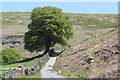
Large beech tree, Cwm Tylri
Solitary tree next to byway on the hillside with the flank of Mynydd Coety beyond.
Image: © M J Roscoe
Taken: 15 May 2019
0.08 miles
5
Gwrhyd
The red barn (very Vermont) belongs to the farm Gwrhyd, which lies to the east of the pumping station for the Cwmtillery reservoir, just in the square.
Image: © Graham Horn
Taken: 2 Feb 2008
0.10 miles
6
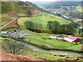
Looking down Cwm Tyleri
The red barn belongs to the farm Gwrhyd. Beyond, the valley descends to the village of the same name, although the lake that can be seen is in the next square to the west.
Image: © Graham Horn
Taken: 2 Feb 2008
0.10 miles
7
Ordnance Survey Cut Mark
This OS cut mark can be found on the wall NW side of the road. It marks a point 364.395m above mean sea level.
Image: © Adrian Dust
Taken: 28 Feb 2019
0.12 miles
8
Autumn in Cwm Tyleri
Autumn's pleasing palette bedecks this upland niche.
Image: © Jeremy Bolwell
Taken: 4 Nov 2012
0.13 miles
10
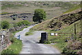
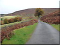
Cattle grid and gate, Cwm Tyleri
The end of the fenced lane, the land beyond to the right and in the distance is common land. The left hand notice on the gate by the Mynydd Coety Grazing Association asks that dogs be controlled on the common land. The central tree is beech tree Image
Image: © M J Roscoe
Taken: 15 May 2019
0.14 miles