IMAGES TAKEN NEAR TO
Queen Street, ABERTILLERY, NP13 1AN
Introduction
This page details the photographs taken nearby to Queen Street, NP13 1AN by members of the Geograph project.
The Geograph project started in 2005 with the aim of publishing, organising and preserving representative images for every square kilometre of Great Britain, Ireland and the Isle of Man.

There are currently over 7.5m images from over14,400 individuals and you can help contribute to the project by visiting https://www.geograph.org.uk
Image Map
Images are licensed for reuse under creativecommons.org/licenses/by-sa/2.0
Notes
- Clicking on the map will re-center to the selected point.
- The higher the marker number, the further away the image location is from the centre of the postcode.
Image Listing (193 Images Found)
Images are licensed for reuse under creativecommons.org/licenses/by-sa/2.0
Image
Details
Distance
1
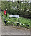
Bilingual Hall Lane name sign, Abertillery
The sign facing Queen Street shows that HALL LANE is LÔN Y NEUADD in Welsh.
Image: © Jaggery
Taken: 16 Apr 2024
0.02 miles
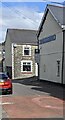
2
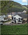
Hall Lane bungalow, Abertillery
Viewed from Queen Street.
Image: © Jaggery
Taken: 16 Apr 2024
0.02 miles
3
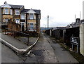
Rear lane in constant use, Abertillery
Viewed from Pant-y-pwdyn Road. The lane is between Duke Street and Princess Street.
The sign on the right has a black background on which white text shows
Rear lane in constant use. Please Keep Clear.
Image: © Jaggery
Taken: 5 Mar 2014
0.04 miles
4
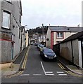
Up Hill Street Abertillery
Looking ENE along Hill Street from Somerset Street.
Image: © Jaggery
Taken: 5 Mar 2014
0.04 miles
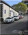
5
Abertillery Funeralcare
The Queen Street side of the Co-op Funeralcare on the corner of Hill Street.
Image: © Jaggery
Taken: 16 Apr 2024
0.04 miles
6
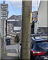
End of traffic calmed area sign, Queen Street, Abertillery
At the NW end of Queen Street. The text is also in Welsh.
Image: © Jaggery
Taken: 16 Apr 2024
0.04 miles
7
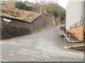
Heol Gerrig, Abertillery
Viewed from the corner of Rhiw Park Road. Heol Gerrig is steep here and gets steeper ahead. Pedestrians use the steps, with railings to lean against for a rest, if needed!
Image: © Jaggery
Taken: 16 Feb 2011
0.04 miles
8
Up Hill Street, Abertillery
Hill Street ascends to the ENE past a Salvation Army church.
Image: © Jaggery
Taken: 16 Apr 2024
0.04 miles
9

House and church, Hill Street, Abertillery
Looking up Hill Street from the corner of Queen Street.
A Salvation Army church is on the right.
Image: © Jaggery
Taken: 16 Apr 2024
0.04 miles
10
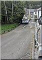
One of many steep descents in Abertillery
Hall Lane descends from Queen Street to Somerset Street.
Image: © Jaggery
Taken: 16 Apr 2024
0.05 miles