IMAGES TAKEN NEAR TO
Bryn Brithdir, BLACKWOOD, NP12 4AA
Introduction
This page details the photographs taken nearby to Bryn Brithdir, NP12 4AA by members of the Geograph project.
The Geograph project started in 2005 with the aim of publishing, organising and preserving representative images for every square kilometre of Great Britain, Ireland and the Isle of Man.

There are currently over 7.5m images from over14,400 individuals and you can help contribute to the project by visiting https://www.geograph.org.uk
Image Map
Images are licensed for reuse under creativecommons.org/licenses/by-sa/2.0
Notes
- Clicking on the map will re-center to the selected point.
- The higher the marker number, the further away the image location is from the centre of the postcode.
Image Listing (30 Images Found)
Images are licensed for reuse under creativecommons.org/licenses/by-sa/2.0
Image
Details
Distance
1
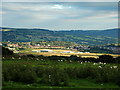
Oakdale Business Park from Pen-Y-Fan
Oakdale Business Park, on the site of an old colliery, seen from the trig point on Pen-Y-Fan
Image: © Aidan Simons
Taken: 11 Jul 2007
0.05 miles
2
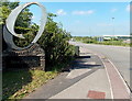
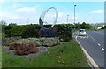
Bryn Brithdir, Oakdale
The Bryn Brithdir name sign is at the edge of a 5-junction roundabout.
The large letter O is for Oakdale. Bryn Brithdir is part of Oakdale Business Park.
Image: © Jaggery
Taken: 18 May 2014
0.08 miles
4
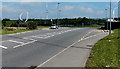
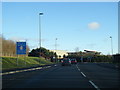
Parkway, Oakdale Business Park
Looking NW across the B4251 Parkway in mid-May 2014.
The distant wind turbines do not appear in a Google Earth Street View taken in September 2011.
Image: © Jaggery
Taken: 18 May 2014
0.09 miles
5
Oakdale Business Park name sign and distant wind turbines
Viewed from the B4251 Parkway.
Image: © Jaggery
Taken: 18 May 2014
0.09 miles
6
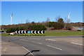
Roundabout, B4251, Pen-y-Fan Industrial Estate
Viewed from Parkway; the two wind turbines in the distance are on Plateau 1. The roundabout is on reclaimed landscaped colliery waste.
Image: © M J Roscoe
Taken: 24 Feb 2016
0.11 miles
7
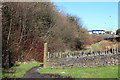
Manmoel Road, near Croespenmaen
This section of the now overgrown former road, replaced by Parkway to its right, has been reduced to a footpath. The blue and white building in the background is Cherry Tree House, a Caerphilly Council office -
Caerphilly Homes.
Image: © M J Roscoe
Taken: 24 Feb 2016
0.12 miles
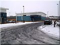
9
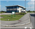
Cherry Tree House, Oakdale Business Park
Office building viewed from Carlton Drive. The name sign on the grass shows Caerphilly Homes.
Image: © Jaggery
Taken: 18 May 2014
0.12 miles
10
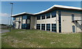
East side of Cherry Tree House, Oakdale Business Park
Office building viewed from Carlton Drive.
Image: © Jaggery
Taken: 18 May 2014
0.12 miles