IMAGES TAKEN NEAR TO
Pengam, BLACKWOOD, NP12 3XY
Introduction
This page details the photographs taken nearby to NP12 3XY by members of the Geograph project.
The Geograph project started in 2005 with the aim of publishing, organising and preserving representative images for every square kilometre of Great Britain, Ireland and the Isle of Man.

There are currently over 7.5m images from over14,400 individuals and you can help contribute to the project by visiting https://www.geograph.org.uk
Image Map
Images are licensed for reuse under creativecommons.org/licenses/by-sa/2.0
Notes
- Clicking on the map will re-center to the selected point.
- The higher the marker number, the further away the image location is from the centre of the postcode.
Image Listing (152 Images Found)
Images are licensed for reuse under creativecommons.org/licenses/by-sa/2.0
Image
Details
Distance
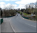
1
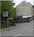
Directions sign, High Street, Pengam
Facing eastbound traffic on the A469 High Street on the approach to the B4252 junction.
Image: © Jaggery
Taken: 11 May 2018
0.02 miles
2
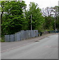
River Terrace gas installation, Pengam
The Wales & West Utilities gas installation is in a locked fenced enclosure on the east bank of the Rhymney River.
Image: © Jaggery
Taken: 11 May 2018
0.02 miles
3
Corner of Bont Cottages and River Terrace, Pengam
Above the Rhymney River.
Image: © Jaggery
Taken: 11 May 2018
0.02 miles
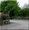
4
Junction of the A469 and B4252 in Pengam
The B4252 Commercial Street from the right joins the A469 High Street.
This is the northern end/start of the B4252 which extends for 3km to Maesycwmmer.
Image: © Jaggery
Taken: 11 May 2018
0.02 miles
5
A469 direction and distances sign, High Street, Pengam
Facing the B4252 Commercial Street junction 2 miles from Bargoed, 3½ from Ystrad Mynach.
Image: © Jaggery
Taken: 11 May 2018
0.02 miles
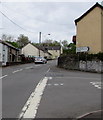
6

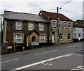
Pengam : High Street houses near the corner of Commercial Street
The houses are on the north side of High Street. The house on the left is opposite the Commercial Street junction. http://www.geograph.org.uk/photo/3440340
Image: © Jaggery
Taken: 1 May 2013
0.03 miles
7
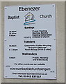
Ebenezer Baptist Church daily activities notice, Pengam
On the wall of this https://www.geograph.org.uk/photo/3440903 church in May 2018.
Image: © Jaggery
Taken: 11 May 2018
0.03 miles
8
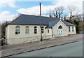
Ebenezer Baptist Church viewed from the south, Pengam
The church is in River Terrace. A tablet on the building shows
EBENEZER ENGLISH BAPTIST CHAPEL BUILT 1907.
Image: © Jaggery
Taken: 1 May 2013
0.03 miles
9
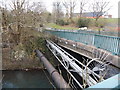
Side view of High Street river bridge, Pengam
Alongside the bridge carrying the A469 High Street over the Rhymney River
are a large-bore pipeline and a group of small-bore pipelines.
Image: © Jaggery
Taken: 1 May 2013
0.03 miles
10
High Street river bridge, Pengam
The A469 High Street crosses over the Rhymney River.
There are dark green railings on both sides of the river bridge.
The left turn is for River Terrace and Ebenezer Chapel.
Image: © Jaggery
Taken: 1 May 2013
0.04 miles