IMAGES TAKEN NEAR TO
Fords Road, BLACKWOOD, NP12 3XS
Introduction
This page details the photographs taken nearby to Fords Road, NP12 3XS by members of the Geograph project.
The Geograph project started in 2005 with the aim of publishing, organising and preserving representative images for every square kilometre of Great Britain, Ireland and the Isle of Man.

There are currently over 7.5m images from over14,400 individuals and you can help contribute to the project by visiting https://www.geograph.org.uk
Image Map
Images are licensed for reuse under creativecommons.org/licenses/by-sa/2.0
Notes
- Clicking on the map will re-center to the selected point.
- The higher the marker number, the further away the image location is from the centre of the postcode.
Image Listing (180 Images Found)
Images are licensed for reuse under creativecommons.org/licenses/by-sa/2.0
Image
Details
Distance
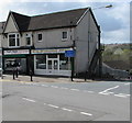
1
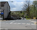
Ford Road, Fleur-de-lis
Ford Road descends from the B4252 High Street towards the Rhymney River. This way for Tir-y-berth.
The sign on the left shows that Ford Road is unsuitable for long vehicles. The text is also in Welsh.
Image: © Jaggery
Taken: 26 Apr 2018
0.01 miles
2

Ford Road bungalows, Fleur-de-lis
On the corner of Glanddu Road. Originally, bungalow was used in English for a lightly-built house, with a veranda and one storey. In current UK usage it is a convenient word for any one-storey dwelling.
Image: © Jaggery
Taken: 26 Apr 2018
0.03 miles
3
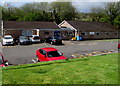
Pengam Health Centre in Fleur-de-lis
Located below Glan-yr-Afon Lane, Pengam Health Centre is on the east bank of the Rhymney River.
Image: © Jaggery
Taken: 26 Apr 2018
0.03 miles
4
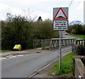
Warning sign - Humps for 280 yards, Fleur-de-lis
Located here https://www.geograph.org.uk/photo/3448400 at the western end of Ford Road on the approach to Tir-y-berth. The sign text is also in Welsh.
Image: © Jaggery
Taken: 26 Apr 2018
0.04 miles
5
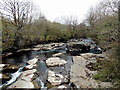
Rocky Rhymney River, Fleur de Lys
The rocky area of the river, immediately north of this road bridge, http://www.geograph.org.uk/photo/3448343 contrasts with the river on the other side of the bridge. http://www.geograph.org.uk/photo/3448435
Viewed from Ford Road, no doubt named at the time when the rocks gave a passage across the river before there was a bridge here.
Image: © Jaggery
Taken: 3 May 2013
0.04 miles
6
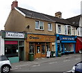
Croeso Christian Bookshop and Coffee Shop, Fleur de Lys
Located in High Street, Croeso is flanked by Elm Barbers on the left
and Mike's Fish Bar on the right.
Fleur de Lys is a village adjacent to Pengam, to the SE of Blackwood.
Image: © Jaggery
Taken: 3 May 2013
0.04 miles
7
Noel's Meats in High Street, Fleur-de-lis
The family butchers shop at 4 High Street is next door to C&S Heating Spares on the corner of Ford Road.
Image: © Jaggery
Taken: 26 Apr 2018
0.04 miles
8
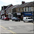
Mike's Fish Bar in Fleur-de-lis
Fish & chips shop at 6 High Street in Fleur-de-lis.
Image: © Jaggery
Taken: 26 Apr 2018
0.05 miles
9

OG Barbershop and The Grapevine, High Street, Fleur-de-lis
The Grapevine is a family-run greengrocers.
Image: © Jaggery
Taken: 11 May 2018
0.05 miles
10

Tir-y-berth: Beatty Street descends towards the Rhymney River
Viewed from the corner of Horner Street, looking towards the village of Fleur de Lys.
Image: © Jaggery
Taken: 3 May 2013
0.05 miles