IMAGES TAKEN NEAR TO
River Terrace, BLACKWOOD, NP12 3XB
Introduction
This page details the photographs taken nearby to River Terrace, NP12 3XB by members of the Geograph project.
The Geograph project started in 2005 with the aim of publishing, organising and preserving representative images for every square kilometre of Great Britain, Ireland and the Isle of Man.

There are currently over 7.5m images from over14,400 individuals and you can help contribute to the project by visiting https://www.geograph.org.uk
Image Map
Images are licensed for reuse under creativecommons.org/licenses/by-sa/2.0
Notes
- Clicking on the map will re-center to the selected point.
- The higher the marker number, the further away the image location is from the centre of the postcode.
Image Listing (143 Images Found)
Images are licensed for reuse under creativecommons.org/licenses/by-sa/2.0
Image
Details
Distance
1
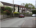
Houses on the east side of River Terrace, Pengam
River Terrace is on the east bank of the Rhymney River.
Image: © Jaggery
Taken: 11 May 2018
0.01 miles
2
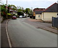
Bend in River Terrace, Pengam
River Terrace is on the east bank of the Rhymney River. Ebenezer Baptist Church https://www.geograph.org.uk/photo/3440903 is on the right.
Image: © Jaggery
Taken: 11 May 2018
0.01 miles
3
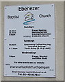
Ebenezer Baptist Church daily activities notice, Pengam
On the wall of this https://www.geograph.org.uk/photo/3440903 church in May 2018.
Image: © Jaggery
Taken: 11 May 2018
0.02 miles
4
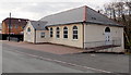
Ebenezer Baptist Church viewed from the north, Pengam
The church is in River Terrace. A tablet on the building shows
EBENEZER ENGLISH BAPTIST CHAPEL BUILT 1907.
Image: © Jaggery
Taken: 1 May 2013
0.02 miles
5
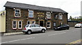
Smiths Arms, Pengam
Pub at 1 Commercial Street. https://www.geograph.org.uk/photo/5769772 to the name sign.
Image: © Jaggery
Taken: 11 May 2018
0.02 miles
6
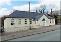
Ebenezer Baptist Church viewed from the south, Pengam
The church is in River Terrace. A tablet on the building shows
EBENEZER ENGLISH BAPTIST CHAPEL BUILT 1907.
Image: © Jaggery
Taken: 1 May 2013
0.02 miles
7
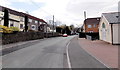
River Terrace, Pengam
Viewed from the A469 High Street end looking south past the Ebenezer Baptist Church http://www.geograph.org.uk/photo/3440899
on the right. The river in the name of the street is the Rhymney, which flows past the back of the church.
Image: © Jaggery
Taken: 1 May 2013
0.02 miles
8
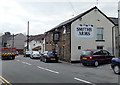
Smiths Arms, Pengam
Pub in Commercial Street near its northern end at the High Street junction.
Image: © Jaggery
Taken: 1 May 2013
0.03 miles
9
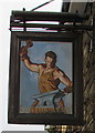
Smiths Arms name sign, Pengam
Hanging from a wall bracket here. https://www.geograph.org.uk/photo/5769765
Image: © Jaggery
Taken: 11 May 2018
0.03 miles
10

Northern end of Commercial Street, Pengam
Viewed from High Street looking south towards the Smiths Arms. http://www.geograph.org.uk/photo/3440269 The sign on the right pointing along Commercial Street (the B4252) shows ½ mile to Fleur-de-Lys and 1 mile to Maesycwmmer.
Image: © Jaggery
Taken: 1 May 2013
0.03 miles