IMAGES TAKEN NEAR TO
Nyddfa Yard, BLACKWOOD, NP12 3UZ
Introduction
This page details the photographs taken nearby to Nyddfa Yard, NP12 3UZ by members of the Geograph project.
The Geograph project started in 2005 with the aim of publishing, organising and preserving representative images for every square kilometre of Great Britain, Ireland and the Isle of Man.

There are currently over 7.5m images from over14,400 individuals and you can help contribute to the project by visiting https://www.geograph.org.uk
Image Map
Images are licensed for reuse under creativecommons.org/licenses/by-sa/2.0
Notes
- Clicking on the map will re-center to the selected point.
- The higher the marker number, the further away the image location is from the centre of the postcode.
Image Listing (161 Images Found)
Images are licensed for reuse under creativecommons.org/licenses/by-sa/2.0
Image
Details
Distance
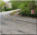
1
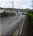
Unnamed side road in Pengam
From the west side of Commercial Street the road leads to a garage on the east bank of the Rhymney River.
Image: © Jaggery
Taken: 26 Apr 2018
0.02 miles
2
Wires over Commercial Street, Pengam
Single thicker wire in the foreground, several thinner wires in the background, viewed from St David's Road.
Image: © Jaggery
Taken: 26 Apr 2018
0.03 miles
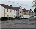
3
West side of Commercial Street, Fleur-de-lis
Houses on the west side of the B4252 Commercial Street viewed looking away from the centre of Fleur-de-lis.
Image: © Jaggery
Taken: 26 Apr 2018
0.04 miles
4
Direction signs at the western end of St David's Road, Pengam
Left for shops (siopau in Welsh) or right for Bargoed.
Image: © Jaggery
Taken: 26 Apr 2018
0.04 miles
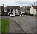
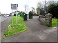
5
Red Royal Mail drop box, Commercial Street, Pengam
Image: © Jaggery
Taken: 26 Apr 2018
0.05 miles
6
Two telecoms cabinets above St David's Road, Pengam
Near the corner of Commercial Street viewed in April 2018.
No cabinets were here in an April 2011 Google Earth Street View.
Image: © Jaggery
Taken: 26 Apr 2018
0.05 miles
7
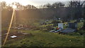
Cemetery in Fleur-de-Lys
No longer used.
Image: © Mike Williams
Taken: 30 Dec 2019
0.05 miles
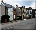
8
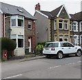
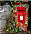
Queen Elizabeth II postbox, Commercial Street, Fleur-de-lis
In a brick pillar on the west side of the B4252 Commercial Street.
Image: © Jaggery
Taken: 11 May 2018
0.06 miles
9
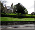
St David's Church, Fleur-de-lis
The church is part of the Rectorial Benefice of Upper Islwyn in the Church in Wales Diocese of Monmouth.
The church was built in 1893-1894 to the designs of architect E.M. Bruce Vaughan of Cardiff.
Image: © Jaggery
Taken: 26 Apr 2018
0.06 miles
10
Queen Elizabeth II postbox in a brick pillar, Fleur-de-lis
On the west side of the B4252 Commercial Street, on the left here. https://www.geograph.org.uk/photo/6135875
Image: © Jaggery
Taken: 26 Apr 2018
0.06 miles