IMAGES TAKEN NEAR TO
Victoria Road, BLACKWOOD, NP12 3UP
Introduction
This page details the photographs taken nearby to Victoria Road, NP12 3UP by members of the Geograph project.
The Geograph project started in 2005 with the aim of publishing, organising and preserving representative images for every square kilometre of Great Britain, Ireland and the Isle of Man.

There are currently over 7.5m images from over14,400 individuals and you can help contribute to the project by visiting https://www.geograph.org.uk
Image Map
Images are licensed for reuse under creativecommons.org/licenses/by-sa/2.0
Notes
- Clicking on the map will re-center to the selected point.
- The higher the marker number, the further away the image location is from the centre of the postcode.
Image Listing (5 Images Found)
Images are licensed for reuse under creativecommons.org/licenses/by-sa/2.0
Image
Details
Distance
2
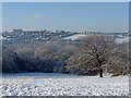
Snowy view across the Rhymney Valley
From Image looking west towards Hengoed.
Image: © Robin Drayton
Taken: 22 Dec 2009
0.17 miles
3
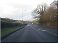
A4049 between Fleur-de-lis and Gellihaf
Looking towards Gellihaf near the former Gwent Abattoir
Image: © Geographer
Taken: Unknown
0.23 miles
4
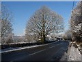
A4049 at Gelli-h
Looking north towards Fleur-de-lis.
Image: © Robin Drayton
Taken: 22 Dec 2009
0.24 miles
5
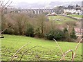
Old Railway Viaduct
Spanning the valley, this disused viaduct now carries a cycle/footpath.
Image: © Stuart Wilding
Taken: 11 Mar 2007
0.25 miles