IMAGES TAKEN NEAR TO
Farm View, BLACKWOOD, NP12 3TW
Introduction
This page details the photographs taken nearby to Farm View, NP12 3TW by members of the Geograph project.
The Geograph project started in 2005 with the aim of publishing, organising and preserving representative images for every square kilometre of Great Britain, Ireland and the Isle of Man.

There are currently over 7.5m images from over14,400 individuals and you can help contribute to the project by visiting https://www.geograph.org.uk
Image Map
Images are licensed for reuse under creativecommons.org/licenses/by-sa/2.0
Notes
- Clicking on the map will re-center to the selected point.
- The higher the marker number, the further away the image location is from the centre of the postcode.
Image Listing (40 Images Found)
Images are licensed for reuse under creativecommons.org/licenses/by-sa/2.0
Image
Details
Distance
1
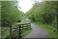
NCR 468 in Bargoed Woodland Park
National Cycle Route 468 above the Rhymney River. The route goes to the left in front of the bench in the distance. The sign points to steps leading to a footbridge to Gilfach.
Image: © M J Roscoe
Taken: 11 May 2017
0.04 miles
2
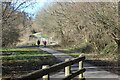
NCR 468, Bargoed Woodland Park
Viewed from the top of the steps in Image The cycle route goes down to the left in front of the bench to run alongside the river towards Bargoed.
Image: © M J Roscoe
Taken: 16 Mar 2021
0.05 miles
3
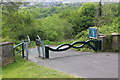
Entrance to Bargoed Woodland Park, Britannia
Squeeze stile entrance to the park from the lower end of Angel Lane. The green gate is locked shut.
Image: © M J Roscoe
Taken: 11 May 2017
0.05 miles
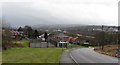
4
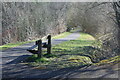
Path down to Bargoed Gauging Station
Path leading to gauging station Image
Image: © M J Roscoe
Taken: 16 Mar 2021
0.07 miles
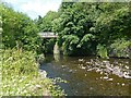
5
Footbridge, River Rhymney, Bargoed Woodland Park
Bridge, seen in distance in Image, and steps up to NCR 468.
Image: © M J Roscoe
Taken: 16 Mar 2021
0.07 miles
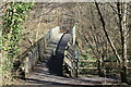
6
Footbridge over the Rhymney River
Bargoed Woodland Park / Parc Coetir Bargod.
Image: © Robin Drayton
Taken: 23 Aug 2013
0.07 miles
8
Rhymney River below A469 bridge
Looking downstream from same camera position as Image in Bargoed Woodland Park
Image: © M J Roscoe
Taken: 11 May 2017
0.08 miles
9
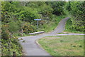
Path crossroads, Bargoed Woodland Park
The meeting of four paths close to the entrance going away from the camera from Angel Lane Image The left arm of the signpost reads, 'Aberbargoed' (in English and Welsh), the right, 'Pengam' and that to the camera, 'Bargoed'.
Image: © M J Roscoe
Taken: 11 May 2017
0.09 miles
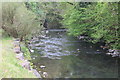
10
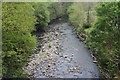
Rhymney River below footbridge, Bargoed Woodland Park
Looking downstream from a wooden footbridge; the numerous dry stones in the river bed indicate that the water level is low after a dry April.
Image: © M J Roscoe
Taken: 11 May 2017
0.09 miles