1
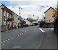
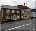
High Street houses, Pengam
There are no shops in High Street Pengam. This row of houses is on the south side
of High Street, viewed from the southern entrance http://www.geograph.org.uk/photo/3440221 to Parc Coetir Bargod.
Image: © Jaggery
Taken: 1 May 2013
0.03 miles
2
High Street entrance to Bargoed Woodland Park
This southern entrance has the Park's characteristic gate.
Image: © M J Roscoe
Taken: 16 Mar 2021
0.03 miles
3
Entrance to Bargoed Woodland Park
Image: © Gareth James
Taken: 19 Feb 2015
0.05 miles
4
Western end of Waun Borfa Road, Pengam
Viewed from Waun Borfa Road across the A4049 Pengam Road towards High Street, Pengam.
Image: © Jaggery
Taken: 1 May 2013
0.05 miles
5
Southern entrance to Parc Coetir Bargod, Pengam
Viewed across High Street Pengam. Parc Coetir Bargod is a country park on the site of three former collieries, with old woodlands. The formerly polluted Rhymney River which flows through the park
is now home to a variety of wildlife such as otters, dippers, herons and kingfishers.
Image: © Jaggery
Taken: 1 May 2013
0.05 miles
6
Closed Station at Pengam (Mon.), with a Standard GW Pannier 0-6-0T
View southwards, towards Maes-y-Cwmmer and Newport: ex-Brecon & Merthyr, later GWR, Newport - Brecon line. The station, together with the passenger service had been closed on 31/12/62, but the line remained open for a few more years for goods. (Pengam (Glam.) station, across the Rhymney River to the west, remains open on the Rhymney Railway line).
Image: © Ben Brooksbank
Taken: 5 Apr 1965
0.13 miles
7
Hilly High Street, Pengam
The A469 High Street climbs away from the valley of the Rhymney River
past the right turn for Commercial Street. http://www.geograph.org.uk/photo/3440340
Image: © Jaggery
Taken: 1 May 2013
0.13 miles
8
Islwyn Close bungalows, Pengam
Originally, bungalow was used in English for a lightly-built house, with a veranda and one storey.
In current UK usage it is a convenient word for any one-storey dwelling.
Image: © Jaggery
Taken: 11 May 2018
0.15 miles
9
Landslip by River Rhymney, Bargoed Woodland Park
Landscaped colliery waste on the left bank of the river has slipped down to the edge of the river.
Image: © M J Roscoe
Taken: 16 Mar 2021
0.15 miles
10
A469 direction and distances sign, High Street, Pengam
Facing the B4252 Commercial Street junction 2 miles from Bargoed, 3½ from Ystrad Mynach.
Image: © Jaggery
Taken: 11 May 2018
0.15 miles


