IMAGES TAKEN NEAR TO
Nydfa Road, BLACKWOOD, NP12 3SX
Introduction
This page details the photographs taken nearby to Nydfa Road, NP12 3SX by members of the Geograph project.
The Geograph project started in 2005 with the aim of publishing, organising and preserving representative images for every square kilometre of Great Britain, Ireland and the Isle of Man.

There are currently over 7.5m images from over14,400 individuals and you can help contribute to the project by visiting https://www.geograph.org.uk
Image Map
Images are licensed for reuse under creativecommons.org/licenses/by-sa/2.0
Notes
- Clicking on the map will re-center to the selected point.
- The higher the marker number, the further away the image location is from the centre of the postcode.
Image Listing (143 Images Found)
Images are licensed for reuse under creativecommons.org/licenses/by-sa/2.0
Image
Details
Distance
1
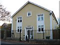
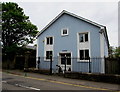
Former Baptist Chapel, Pengam
This private residence was formerly Capel y Bont Welsh Baptist Church, built in 1857 and extended in 1865. Bont means bridge and the original chapel was sited near the bridge over the river Rhymney. The name was retained when the chapel was relocated to this site.
Image: © Robin Drayton
Taken: 31 Oct 2007
0.01 miles
2
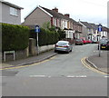
West along Nydfa Road, Pengam
Towards River Terrace. One-way signs face Commercial Street.
Image: © Jaggery
Taken: 11 May 2018
0.02 miles
3
Entrance to Ysgol Gymraeg Trelyn, Pengam
From Commercial Street. Ysgol Gymraeg Trelyn is a Welsh medium primary school.
Image: © Jaggery
Taken: 11 May 2018
0.04 miles
4
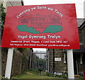
Ysgol Gymraeg Trelyn name sign, Pengam
On the left here. https://www.geograph.org.uk/photo/5769871 The Welsh Cymraeg yw Iaith ein Taith means Welsh is the Language of our Journey.
Image: © Jaggery
Taken: 11 May 2018
0.04 miles
5
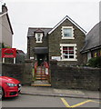
Capel-y-Bont, Commercial Street, Pengam
The Welsh text on the tablet shows that Capel-y-Bont Baptist Chapel was built
in 1857, rebuilt in 1865. The chapel was converted to residential use in 1997.
Image: © Jaggery
Taken: 11 May 2018
0.04 miles
6
Converted former Baptist Chapel, Commercial Street, Pengam
The Welsh text on the tablet shows that Capel-y-Bont Baptist Chapel was built
in 1857, rebuilt in 1865. The chapel was converted to residential use in 1997.
The house is named Capel-y-Bont.
Image: © Jaggery
Taken: 11 May 2018
0.04 miles
7
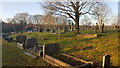
Cemetery in Fleur-de-Lys
No longer used for burials.
Image: © Mike Williams
Taken: 30 Dec 2019
0.04 miles
8
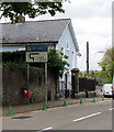
Unusually precise distance on a Commercial Street traffic sign, Pengam
The sign faces northbound traffic on the B4252 Commercial Street.
Faded in May 2018, the top part of the sign shows No Right Turn 317 yards ahead.
The green cones are intended to prevent vehicles parking near a school.
Capel-y-Bont https://www.geograph.org.uk/photo/5770920 is behind the sign.
Image: © Jaggery
Taken: 11 May 2018
0.05 miles
9
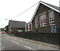
Ysgol Gymraeg Trelyn, Pengam
Welsh medium primary school on the west side of Commercial Street.
Image: © Jaggery
Taken: 11 May 2018
0.05 miles
10
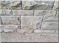
Ordnance Survey Cut Mark
This OS cut mark can be found on the west face of the school. It marks a point 139.815m above mean sea level.
Image: © Adrian Dust
Taken: 12 Feb 2021
0.05 miles