IMAGES TAKEN NEAR TO
Pengam Road, BLACKWOOD, NP12 3SL
Introduction
This page details the photographs taken nearby to Pengam Road, NP12 3SL by members of the Geograph project.
The Geograph project started in 2005 with the aim of publishing, organising and preserving representative images for every square kilometre of Great Britain, Ireland and the Isle of Man.

There are currently over 7.5m images from over14,400 individuals and you can help contribute to the project by visiting https://www.geograph.org.uk
Image Map
Images are licensed for reuse under creativecommons.org/licenses/by-sa/2.0
Notes
- Clicking on the map will re-center to the selected point.
- The higher the marker number, the further away the image location is from the centre of the postcode.
Image Listing (81 Images Found)
Images are licensed for reuse under creativecommons.org/licenses/by-sa/2.0
Image
Details
Distance
1
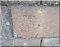
Ordnance Survey Cut Mark
This OS cut mark can be found on the wall east side of Pengam Road. It marks a point 165.479m above mean sea level.
Image: © Adrian Dust
Taken: 31 Aug 2019
0.02 miles
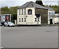
2
Wendy's Doggie Do's in Pengam
Dog grooming salon in Unit 1, Fair View Garage, Woodland Place,
on the corner of St David's Road viewed in April 2018.
UPDATE January 2019. The business has moved to Unit G4, Bowen Industrial Estate, Aberbargoed and is now known as Gingertykes Groomers.
Image: © Jaggery
Taken: 26 Apr 2018
0.13 miles
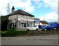
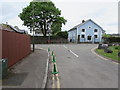
3
The Majors, Pengam
Pub on the corner of Fair View and Pengam Road viewed in April 2018.
An August 2011 Google Earth Street View shows the Harlequin Club on this corner.
Image: © Jaggery
Taken: 26 Apr 2018
0.13 miles
4
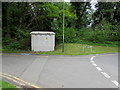
Bont Close electricity substation, Pengam
The grey cabinet is a Western Power Distribution electricity substation.
Image: © Jaggery
Taken: 11 May 2018
0.15 miles
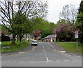
5
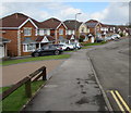
Bramblewood Court houses, Pengam
Viewed from the corner of St David's Road.
Image: © Jaggery
Taken: 26 Apr 2018
0.15 miles
6
Wooden bench, Bont Close, Pengam
One of several similar benches on the grass on east side of Bont Close, opposite these https://www.geograph.org.uk/photo/5770762 bungalows.
Image: © Jaggery
Taken: 11 May 2018
0.16 miles
7
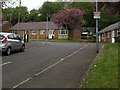
Islwyn Close bungalows, Pengam
Originally, bungalow was used in English for a lightly-built house, with a veranda and one storey.
In current UK usage it is a convenient word for any one-storey dwelling.
Image: © Jaggery
Taken: 11 May 2018
0.16 miles
8
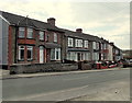
High Street houses, Pengam
There are no shops in High Street Pengam. This row of houses is on the south side
of High Street, viewed from the southern entrance http://www.geograph.org.uk/photo/3440221 to Parc Coetir Bargod.
Image: © Jaggery
Taken: 1 May 2013
0.16 miles
9
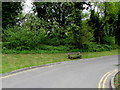
Green cones at the edge of Bont Close and Commercial Street, Pengam
The green cones are intended to prevent vehicles parking near a school.
They shouldn't be necessary on the camera (Bont Close) side of the junction
because the double yellow lines indicate no parking at any time.
The former Baptist chapel, now a house named Capel-y-Bont, is on the right. https://www.geograph.org.uk/photo/5770920
Image: © Jaggery
Taken: 11 May 2018
0.16 miles
10
Islwyn Close, Pengam
Cul-de-sac on the east side of Commercial Street.
Image: © Jaggery
Taken: 11 May 2018
0.16 miles