1
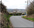
Northern end of Dylan Avenue, Cefn Fforest, Blackwood
A view south from Waun Borfa Road.
Image: © Jaggery
Taken: 1 May 2013
0.01 miles
2
Western boundary of Cefn Fforest, Blackwood
Waun Borfa Road climbs towards the green Cefn Fforest boundary sign.
Image: © Jaggery
Taken: 1 May 2013
0.07 miles
3
Rural part of Waun Borfa Road at the edge of Cefn Fforest, Blackwood
The houses http://www.geograph.org.uk/photo/3439551 in Waun Borfa Road are to the east, behind the camera.
Ahead, there are no houses - or pavements. The walker needs to be circumspect here.
Behind the pole on the right is the grey back of the Cefn Fforest boundary sign.
Image: © Jaggery
Taken: 1 May 2013
0.08 miles
4
Waun Borfa Road houses, Cefn Fforest, Blackwood
The houses are on the north side of Waun Borfa Road. The corner is the junction with Pencoed Avenue.
Image: © Jaggery
Taken: 1 May 2013
0.08 miles
5
St Thomas church, Cefn Fforest, Blackwood viewed from the NW
The church, on the corner of Bryngoleu Street and Waunborfa Road, Cefn Fforest, is in the parish of Fleur-de-Lis, diocese of Monmouth, Church in Wales.
Viewed from the opposite side. http://www.geograph.org.uk/photo/2253553
Image: © Jaggery
Taken: 17 Jan 2011
0.09 miles
6
St Thomas church hall, Cefn Fforest, Blackwood
Set back from the south side of Waunborfa Road, located alongside the church http://www.geograph.org.uk/photo/2253553
Image: © Jaggery
Taken: 17 Jan 2011
0.09 miles
7
St Thomas church, Cefn Fforest, Blackwood viewed from the east
The church, on the corner of Bryngoleu Street and Waunborfa Road, Cefn Fforest, is in the parish of Fleur-de-Lis, diocese of Monmouth, Church in Wales.
Viewed from the opposite side. http://www.geograph.org.uk/photo/2253569
Image: © Jaggery
Taken: 17 Jan 2011
0.09 miles
8
Dylan Avenue, Cefn Fforest, Blackwood
Dylan Avenue climbs away from Pwllglas Road and Cefn Fforest Fire Station. http://www.geograph.org.uk/photo/3439398
Image: © Jaggery
Taken: 1 May 2013
0.09 miles
9
Cefn Fforest Avenue, Cefn Fforest, Blackwood
Cefn Fforest Avenue climbs away from Pwllglas Road.
Image: © Jaggery
Taken: 1 May 2013
0.10 miles
10
Bryngoleu Street, Cefn Fforest, Blackwood
Houses on the west side of Bryngoleu Street, viewed from near the leisure centre.http://www.geograph.org.uk/photo/2253638
Image: © Jaggery
Taken: 17 Jan 2011
0.10 miles


