IMAGES TAKEN NEAR TO
Bryn Road, BLACKWOOD, NP12 3LY
Introduction
This page details the photographs taken nearby to Bryn Road, NP12 3LY by members of the Geograph project.
The Geograph project started in 2005 with the aim of publishing, organising and preserving representative images for every square kilometre of Great Britain, Ireland and the Isle of Man.

There are currently over 7.5m images from over14,400 individuals and you can help contribute to the project by visiting https://www.geograph.org.uk
Image Map
Images are licensed for reuse under creativecommons.org/licenses/by-sa/2.0
Notes
- Clicking on the map will re-center to the selected point.
- The higher the marker number, the further away the image location is from the centre of the postcode.
Image Listing (39 Images Found)
Images are licensed for reuse under creativecommons.org/licenses/by-sa/2.0
Image
Details
Distance
1
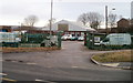
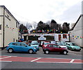
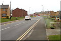
Balfour Beatty Cefn Fforest Depot, Blackwood
Located on Bryn Road, near the Bloomfield Road / Pwllglas Road junction.
Balfour Beatty Plant & Fleet Services provide national coverage from depots in the UK. Services include crane, accommodation and site, railway trackside plant and equipment, construction plant, and vehicle fleet.
Image: © Jaggery
Taken: 17 Jan 2011
0.06 miles
2
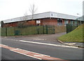
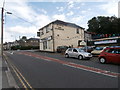
Oasis Christian Centre, Cefn Fforest, Blackwood
The Centre is located in a large rectangular building, about 45 metres by 40 metres, on the east side of Bryn Road.
Image: © Jaggery
Taken: 17 Jan 2011
0.06 miles
4
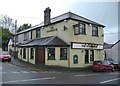
The Stonehouse pub. Cefn Fforest, Blackwood
Pub on the corner of Bryn Road and Pwllglas Road, viewed from the corner of Bloomfield Road.
Image: © Jaggery
Taken: 17 Jan 2011
0.11 miles
5
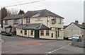
Stonehouse Garage Blackwood
The car sales and repairs business in Pwllglas Road, Cefn Fforest, Blackwood,
is alongside the Stonehouse pub. http://www.geograph.org.uk/photo/2252256
Image: © Jaggery
Taken: 1 May 2013
0.11 miles
7
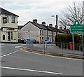
Cefn Fforest boundary sign
The sign is at the crossroads of Bryn Road, Bloomfield Road and Pwllglas Road.
The Stonehouse http://www.geograph.org.uk/photo/2252256 is on the left.
Image: © Jaggery
Taken: 1 May 2013
0.12 miles
8
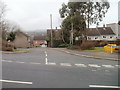
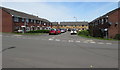
Twyn Gardens, Cefn Fforest, Blackwood
Viewed across Bryn Road. Twyn Gardens contains about 100 houses, built c1970.
Image: © Jaggery
Taken: 17 Jan 2011
0.12 miles
9
Croeso Square, Blackwood
On the north side of Apollo Way.
Image: © Jaggery
Taken: 17 May 2018
0.13 miles
10
Apollo Way, Blackwood
Viewed from near the entrance http://www.geograph.org.uk/photo/2341484 to Blackwood Primary School.
Image: © Jaggery
Taken: 4 Apr 2011
0.13 miles