IMAGES TAKEN NEAR TO
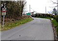
Waunborfa Road, BLACKWOOD, NP12 3LB
Introduction
This page details the photographs taken nearby to Waunborfa Road, NP12 3LB by members of the Geograph project.
The Geograph project started in 2005 with the aim of publishing, organising and preserving representative images for every square kilometre of Great Britain, Ireland and the Isle of Man.

There are currently over 7.5m images from over14,400 individuals and you can help contribute to the project by visiting https://www.geograph.org.uk
Image Map
Images are licensed for reuse under creativecommons.org/licenses/by-sa/2.0
Notes
- Clicking on the map will re-center to the selected point.
- The higher the marker number, the further away the image location is from the centre of the postcode.
Image Listing (46 Images Found)
Images are licensed for reuse under creativecommons.org/licenses/by-sa/2.0
Image
Details
Distance
1
Western boundary of Cefn Fforest, Blackwood
Waun Borfa Road climbs towards the green Cefn Fforest boundary sign.
Image: © Jaggery
Taken: 1 May 2013
0.03 miles
2
Rural part of Waun Borfa Road at the edge of Cefn Fforest, Blackwood
The houses http://www.geograph.org.uk/photo/3439551 in Waun Borfa Road are to the east, behind the camera.
Ahead, there are no houses - or pavements. The walker needs to be circumspect here.
Behind the pole on the right is the grey back of the Cefn Fforest boundary sign.
Image: © Jaggery
Taken: 1 May 2013
0.03 miles
3
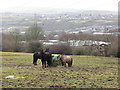
Horses near Pengam in the Rhymney Valley
Image: © Gareth James
Taken: 19 Feb 2015
0.06 miles
4
Northern end of Dylan Avenue, Cefn Fforest, Blackwood
A view south from Waun Borfa Road.
Image: © Jaggery
Taken: 1 May 2013
0.07 miles
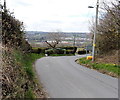
5
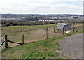
Field alongside Waun Borfa Road west of Cefn Fforest
This location, at about 200 metres (c655 ft) above sea level, gives good views of Pengam and neighbouring locations.
Image: © Jaggery
Taken: 1 May 2013
0.07 miles
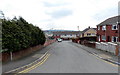
6
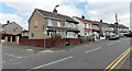
Waun Borfa Road houses, Cefn Fforest, Blackwood
The houses are on the north side of Waun Borfa Road. The corner is the junction with Pencoed Avenue.
Image: © Jaggery
Taken: 1 May 2013
0.09 miles
7
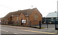
St Thomas church, Cefn Fforest, Blackwood viewed from the NW
The church, on the corner of Bryngoleu Street and Waunborfa Road, Cefn Fforest, is in the parish of Fleur-de-Lis, diocese of Monmouth, Church in Wales.
Viewed from the opposite side. http://www.geograph.org.uk/photo/2253553
Image: © Jaggery
Taken: 17 Jan 2011
0.12 miles
8
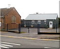
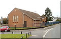
St Thomas church hall, Cefn Fforest, Blackwood
Set back from the south side of Waunborfa Road, located alongside the church http://www.geograph.org.uk/photo/2253553
Image: © Jaggery
Taken: 17 Jan 2011
0.12 miles
9
St Thomas church, Cefn Fforest, Blackwood viewed from the east
The church, on the corner of Bryngoleu Street and Waunborfa Road, Cefn Fforest, is in the parish of Fleur-de-Lis, diocese of Monmouth, Church in Wales.
Viewed from the opposite side. http://www.geograph.org.uk/photo/2253569
Image: © Jaggery
Taken: 17 Jan 2011
0.12 miles
10
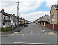
Pencoed Avenue, Cefn Fforest, Blackwood
Looking north across Waun Borfa Road.
Image: © Jaggery
Taken: 1 May 2013
0.13 miles