IMAGES TAKEN NEAR TO
Clos Claerwen, BLACKWOOD, NP12 3FZ
Introduction
This page details the photographs taken nearby to Clos Claerwen, NP12 3FZ by members of the Geograph project.
The Geograph project started in 2005 with the aim of publishing, organising and preserving representative images for every square kilometre of Great Britain, Ireland and the Isle of Man.

There are currently over 7.5m images from over14,400 individuals and you can help contribute to the project by visiting https://www.geograph.org.uk
Image Map
Images are licensed for reuse under creativecommons.org/licenses/by-sa/2.0
Notes
- Clicking on the map will re-center to the selected point.
- The higher the marker number, the further away the image location is from the centre of the postcode.
Image Listing (13 Images Found)
Images are licensed for reuse under creativecommons.org/licenses/by-sa/2.0
Image
Details
Distance
1
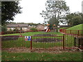
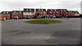
Children's play area, Clos Gronw, Blackwood
Image: © John Lord
Taken: 23 Aug 2017
0.09 miles
2
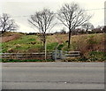
Kissing gate, Fleur de Lys
The kissing gate on the north side of the B4254 leads to a track at the edge of Fleur de Lys,
a village adjacent to Pengam, to the SE of Blackwood.
Image: © Jaggery
Taken: 3 May 2013
0.12 miles
4
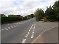
Bryn Rd, Blackwood, at the junction with Gordon Rd
Image: © John Lord
Taken: 23 Aug 2017
0.13 miles
5
Solar panels, Bryn Road, Blackwood
The recently-built houses all have solar panels on their roof.
Image: © Jaggery
Taken: 3 May 2013
0.13 miles
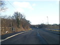
6
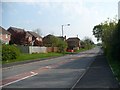
Bryn Road, Blackwood
Approaching the B4254.
Image: © Robin Drayton
Taken: 20 Apr 2011
0.14 miles
7
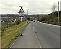
Approach to Ysgol Gyfun Cwm Rhymni, Fleur de Lys
The B4254 from Blackwood descends towards the entrance to Ysgol Gyfun Cwm Rhymni
in Fleur de Lys, a village adjacent to Pengam.
Image: © Jaggery
Taken: 3 May 2013
0.16 miles
9
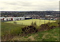
School sports field, Fleur de Lys
Viewed from the B4254. The light green of the sports field in Ysgol Gyfun Cwm Rhymni contrasts with the surrounding darker greens. Fleur de Lys is a village adjacent to Pengam, to the SE of Blackwood.
Image: © Jaggery
Taken: 3 May 2013
0.19 miles
10
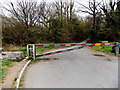
Barrier blocking a lane from Blackwood to Bryn
Viewed from the south side of the B4254 at the edge of Blackwood. The lane http://www.geograph.org.uk/photo/3443238 leads to the area name Bryn near Pontllanfraith. Though the barrier prevents vehicular access, pedestrians can access the lane via the gap between the barrier and a boulder on the left.
Image: © Jaggery
Taken: 3 May 2013
0.21 miles