IMAGES TAKEN NEAR TO
Pantycelyn Lane, BLACKWOOD, NP12 2QG
Introduction
This page details the photographs taken nearby to Pantycelyn Lane, NP12 2QG by members of the Geograph project.
The Geograph project started in 2005 with the aim of publishing, organising and preserving representative images for every square kilometre of Great Britain, Ireland and the Isle of Man.

There are currently over 7.5m images from over14,400 individuals and you can help contribute to the project by visiting https://www.geograph.org.uk
Image Map
Images are licensed for reuse under creativecommons.org/licenses/by-sa/2.0
Notes
- Clicking on the map will re-center to the selected point.
- The higher the marker number, the further away the image location is from the centre of the postcode.
Image Listing (69 Images Found)
Images are licensed for reuse under creativecommons.org/licenses/by-sa/2.0
Image
Details
Distance
1
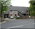
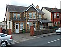
Plough Corner, Pontllanfraith
Viewed across Llanarth Road. Plough Corner contains 8 flats.
Image: © Jaggery
Taken: 8 Aug 2012
0.00 miles
2
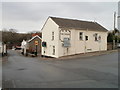
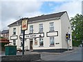
The Plough, Pontllanfraith
Pub on the corner of Newbridge Road (ahead) and Penmaen Road. The left turn is into Llanarth Road.
Image: © Jaggery
Taken: 23 Jan 2011
0.00 miles
3
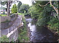
River Sirhowy, Pantycelin Lane, Pontllanfraith
Looking downstream from Commercial Street bridge; Pantycelin Lane on left of picture.
Image: © M J Roscoe
Taken: 16 Jul 2015
0.02 miles
4

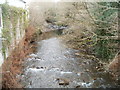
River Sirhowy
Looking downriver from a bridge carrying the B4251.
Image: © Robin Drayton
Taken: 26 May 2011
0.03 miles
5
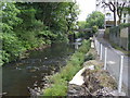
River Sirhowy, Pontllanfraith
Looking upstream to Bridge carrying Commercial Street (B4521, formerly A472); Pantycelin Lane to right of picture.
Image: © M J Roscoe
Taken: 16 Jul 2015
0.03 miles
6
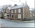
The Plough Inn, Pontllanfraith
Just up the hill from the bridge over the River Sirhowy http://www.geograph.org.uk/photo/2678581 .
Image: © Robin Drayton
Taken: 26 May 2011
0.05 miles
7
The Llanarth, Pontllanfraith
Viewed across Llanarth Road. The Llanarth, or Pontllanfraith WMC (Workingmen's Club) is a social club.
Image: © Jaggery
Taken: 8 Aug 2012
0.06 miles
8
Pontllanfraith Post Office
Commercial Street post office located between Tram Road and the Sirhowy River.
Image: © Jaggery
Taken: 23 Jan 2011
0.06 miles
9
Sirhowy River, Pontllanfraith
The Sirhowy flows towards the camera, located on the B4251 bridge adjacent to Arrow Ford. http://www.geograph.org.uk/photo/2249762
It is unclear whether the rows of thin metal protruding from the side of the Arrow Ford building are outlet pipes or structural support rods.
Image: © Jaggery
Taken: 23 Jan 2011
0.06 miles
10
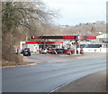
Pontllanfraith Service Station
A Texaco filling station located on the north side of a bend in Commercial Street, Pontllanfraith.
Image: © Jaggery
Taken: 23 Jan 2011
0.06 miles