IMAGES TAKEN NEAR TO
Woodland Road, BLACKWOOD, NP12 2LS
Introduction
This page details the photographs taken nearby to Woodland Road, NP12 2LS by members of the Geograph project.
The Geograph project started in 2005 with the aim of publishing, organising and preserving representative images for every square kilometre of Great Britain, Ireland and the Isle of Man.

There are currently over 7.5m images from over14,400 individuals and you can help contribute to the project by visiting https://www.geograph.org.uk
Image Map
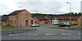
Images are licensed for reuse under creativecommons.org/licenses/by-sa/2.0
Notes
- Clicking on the map will re-center to the selected point.
- The higher the marker number, the further away the image location is from the centre of the postcode.
Image Listing (30 Images Found)
Images are licensed for reuse under creativecommons.org/licenses/by-sa/2.0
Image
Details
Distance
1
Mussel White Court, Springfield, Pontllanfraith
Mussel White Court is a small cul-de-sac of 14 houses, viewed from Millbrook Road.
Image: © Jaggery
Taken: 8 Aug 2012
0.06 miles
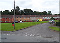
2
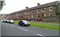
Woodland Road houses, Springfield, Pontllanfraith
Houses on the north side of Woodland Road viewed from the Millbrook Road and Mill Road crossroads.
Image: © Jaggery
Taken: 8 Aug 2012
0.06 miles
3
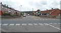
Mill Road, Springfield, Pontllanfraith
Viewed from Millbrook Road at the Woodland Road crossroads.
Image: © Jaggery
Taken: 8 Aug 2012
0.06 miles
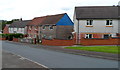
4
Alder Rise, Springfield, Pontllanfraith
Viewed from the corner of Brook Lane and Millbrook Road.
Image: © Jaggery
Taken: 8 Aug 2012
0.07 miles
5
Islwyn Terrace, Pontllanfraith
Islwyn Terrace is a separately-named part of Llanarth Road.
Image: © Jaggery
Taken: 8 Aug 2012
0.10 miles
6
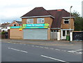
Former Pont Pet Supplies premises to let, Pontllanfraith
There is a To Let sign on the shop on the corner of Meadow Road and Llanarth Road.
An earlier occupier of the premises was Llanarth Stores, newsagents and general stores.
Image: © Jaggery
Taken: 8 Aug 2012
0.12 miles
7
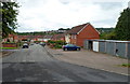
Houses and lock-up garages, Millbrook Road, Springfield, Pontllanfraith
Viewed from the edge of a grassy island. http://www.geograph.org.uk/photo/3073860
Image: © Jaggery
Taken: 8 Aug 2012
0.13 miles
8
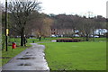
Islwyn Park, Llanarth Road, Pontllanfraith
The eastern edge of Islwyn Park and its entrance from Llanarth Road in the background. The narrow road leads from the bowling green and from industrial premises outside the park.
Image: © M J Roscoe
Taken: 2 Jan 2016
0.14 miles
9
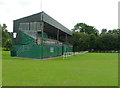
Disused grandstand, Islwyn Park, Pontllanfraith
Islwyn Park is the home ground of Pontllanfraith Rugby Football Club.
The grandstand is located in the SE corner of the park. A notice on the side wall of the grandstand shows DANGEROUS STRUCTURE KEEP OUT.
Image: © Jaggery
Taken: 8 Aug 2012
0.14 miles
10
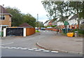
Corner of Meadow Road and Llanarth Road, Pontllanfraith
Viewed across Llanarth Road. A sign next to a yellow grit bin shows that this is the boundary of the Springfield district of Pontllanfraith.
Image: © Jaggery
Taken: 8 Aug 2012
0.14 miles