IMAGES TAKEN NEAR TO
Tram Road Industrial Estate, BLACKWOOD, NP12 2LA
Introduction
This page details the photographs taken nearby to Tram Road Industrial Estate, NP12 2LA by members of the Geograph project.
The Geograph project started in 2005 with the aim of publishing, organising and preserving representative images for every square kilometre of Great Britain, Ireland and the Isle of Man.

There are currently over 7.5m images from over14,400 individuals and you can help contribute to the project by visiting https://www.geograph.org.uk
Image Map
Images are licensed for reuse under creativecommons.org/licenses/by-sa/2.0
Notes
- Clicking on the map will re-center to the selected point.
- The higher the marker number, the further away the image location is from the centre of the postcode.
Image Listing (110 Images Found)
Images are licensed for reuse under creativecommons.org/licenses/by-sa/2.0
Image
Details
Distance
1
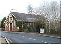
InfoQuest, Pontllanfraith
Youth centre and cyber cafe, Sir Ivor's Road.
InfoQuest provides a drop-in service for young people, similar to a traditional youth club, although the main focus is on providing information and support. InfoQuest is part of the Basement Youth Information Network.
Image: © Jaggery
Taken: 23 Jan 2011
0.03 miles
2
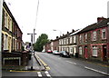
Sir Ivors Road houses, Pontllanfraith
Looking NNE along the B4251 Sir Ivors Road from the corner of Penllwyn Avenue.
Sir Ivors Road is the name used on the local council's website.
Maps also show Sir Ivor Road and Sir Ivor's Road.
Image: © Jaggery
Taken: 20 Jun 2018
0.04 miles
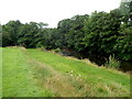
3
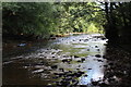
River Sirhowy below Tram Road, Pontllanfraith
Looking upstream from the mouth of Nant Brynar.
Image: © M J Roscoe
Taken: 22 Sep 2016
0.04 miles
4
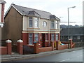
Bryntirion Dental Surgery, Pontllanfraith
Located at the northern end of Sir Ivor's Road, close to the Commercial Street roundabout.
Image: © Jaggery
Taken: 23 Jan 2011
0.05 miles
5
East bank of the Sirhowy, Pontllanfraith
A view of the SW corner of Islwyn Park. The Sirhowy River forms the western boundary of the park.
Image: © Jaggery
Taken: 8 Aug 2012
0.05 miles
6
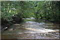
Weir, River Sirhowy, Pontllanfraith
Looking downstream over a small weir, from the same camera position as Image
Image: © M J Roscoe
Taken: 22 Sep 2016
0.06 miles
7
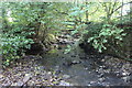
Mouth of Nant Brynar, Pontllanfraith
Stream flowing into the River Sirhowy; a green footbridge can just be discerned upstream.
Image: © M J Roscoe
Taken: 22 Sep 2016
0.06 miles
8
Colin's Fish Bar, Pontllanfraith
Situated in Commercial Street.
Built on a hillside overlooking the Sirhowy Valley.
Image: © Robin Drayton
Taken: 26 May 2011
0.07 miles
9
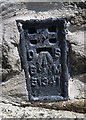
Ordnance Survey Flush Bracket (S1341)
This OS Flush Bracket can be found on the SW face of the Methodist Chapel. It marks a point 142.709m above mean sea level.
Image: © Adrian Dust
Taken: 22 Jun 2019
0.07 miles
10
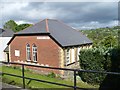
Pontllanfraith Methodist Church
Built on a hillside overlooking the Sirhowy Valley.
Image: © Robin Drayton
Taken: 26 May 2011
0.07 miles