IMAGES TAKEN NEAR TO
Penllwyn Avenue, BLACKWOOD, NP12 2JX
Introduction
This page details the photographs taken nearby to Penllwyn Avenue, NP12 2JX by members of the Geograph project.
The Geograph project started in 2005 with the aim of publishing, organising and preserving representative images for every square kilometre of Great Britain, Ireland and the Isle of Man.

There are currently over 7.5m images from over14,400 individuals and you can help contribute to the project by visiting https://www.geograph.org.uk
Image Map
Images are licensed for reuse under creativecommons.org/licenses/by-sa/2.0
Notes
- Clicking on the map will re-center to the selected point.
- The higher the marker number, the further away the image location is from the centre of the postcode.
Image Listing (89 Images Found)
Images are licensed for reuse under creativecommons.org/licenses/by-sa/2.0
Image
Details
Distance
1
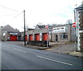
King David Tyres, Pontllanfraith
Pont Tyre Services branch of King David Tyres, Sir Ivor's Road, Pontllanfraith.
This is one of five branches of King David Tyres Ltd, who began trading in 1975.
In addition to being tyre specialists, the branches offer servicing and MoT tests.
Image: © Jaggery
Taken: 23 Jan 2011
0.01 miles
2
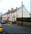
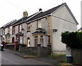
Penllwyn Avenue, Pontllanfraith
Houses on the north side of Penllwyn Avenue viewed from the corner of Sir Ivor's Road.
Penllwyn Avenue is a short street connecting with Gelligroes Road at the far end.
Image: © Jaggery
Taken: 23 Jan 2011
0.01 miles
3
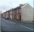
Pontllanfraith : Sir Ivor's Road houses north of Penllwyn Avenue
Houses on the east side of the road, viewed from the corner of Penllwyn Avenue.
Image: © Jaggery
Taken: 23 Jan 2011
0.01 miles
4
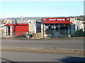
Colin's Fish Bar and Pont News, Pontllanfraith
Two Commercial Street shops, a few tens of metres north of the Tredegar Junction pub. http://www.geograph.org.uk/photo/2240052
http://www.geograph.org.uk/photo/361605 to an interesting side view of Colin's Fish Bar.
Image: © Jaggery
Taken: 20 Jan 2011
0.01 miles
5
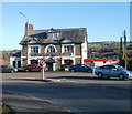
Tredegar Junction pub, Pontllanfraith
Located at the southern end of Commercial Street, Pontllanfraith.
The name of the pub is a reminder that there were formerly two railway stations nearby, Pontllanfraith Low Level and Pontllanfraith High Level. Both were closed in the 1960s.
A small Ladbrokes betting office adjoins the right side of the pub.
Image: © Jaggery
Taken: 20 Jan 2011
0.01 miles
6
Row of houses on the north side of Penllwyn Avenue, Pontllanfraith
On the ascent towards the Gelligroes Road junction.
Image: © Jaggery
Taken: 20 Jun 2018
0.01 miles
7
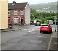
South along Gelligroes Road, Pontllanfraith
The house is on the corner of Penllwyn Avenue.
Image: © Jaggery
Taken: 20 Jun 2018
0.02 miles
8

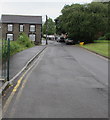
On-street parking, Gelligroes Road, Pontllanfraith
On the east side of Gelligroes Road on the approach to the Penllwyn Avenue junction.
Image: © Jaggery
Taken: 20 Jun 2018
0.02 miles
9
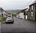
Down Penllwyn Avenue, Pontllanfraith
One-way Penllwyn Avenue descends towards the B4251 Sir Ivors Road, the name used on the local council's website. Maps also show Sir Ivor Road and Sir Ivor's Road.
Image: © Jaggery
Taken: 20 Jun 2018
0.03 miles
10
Junction of Penllwyn Avenue and Sir Ivors Road, Pontllanfraith
Penllwyn Avenue descends towards the B4251 Sir Ivors Road, the name used on the local council's website.
Maps also show Sir Ivor Road and Sir Ivor's Road.
Image: © Jaggery
Taken: 20 Jun 2018
0.03 miles