IMAGES TAKEN NEAR TO
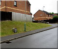
Overdene, BLACKWOOD, NP12 2JS
Introduction
This page details the photographs taken nearby to Overdene, NP12 2JS by members of the Geograph project.
The Geograph project started in 2005 with the aim of publishing, organising and preserving representative images for every square kilometre of Great Britain, Ireland and the Isle of Man.

There are currently over 7.5m images from over14,400 individuals and you can help contribute to the project by visiting https://www.geograph.org.uk
Image Map
Images are licensed for reuse under creativecommons.org/licenses/by-sa/2.0
Notes
- Clicking on the map will re-center to the selected point.
- The higher the marker number, the further away the image location is from the centre of the postcode.
Image Listing (82 Images Found)
Images are licensed for reuse under creativecommons.org/licenses/by-sa/2.0
Image
Details
Distance
1
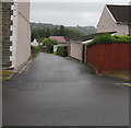
Side road from Gelligroes Road towards Overdene, Pontllanfraith
A Western Power Distribution electricity substation https://www.geograph.org.uk/photo/5820474 is behind the hedge on the right.
Image: © Jaggery
Taken: 20 Jun 2018
0.01 miles
2
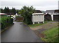
Gelligroes Housing Site electricity substation Pontllanfraith
The grey cabinet alongside the side road from Gelligroes Road to Overdene
is a Western Power Distribution electricity substation. Its identifier is S/S 551511
Image: © Jaggery
Taken: 20 Jun 2018
0.03 miles
3
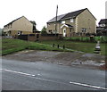
Semis above Newport Road, Pontllanfraith
Semi-detached houses above the west side of the B4251 Newport Road.
Image: © Jaggery
Taken: 20 Jun 2018
0.04 miles
4
Overdene, Pontllanfraith
Cul-de-sac viewed across Gelli Lane.
Image: © Jaggery
Taken: 20 Jun 2018
0.05 miles
5
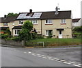
Rooftop solar panels on a Pontllanfraith corner
On the corner of Overdene and Gelli Lane.
Image: © Jaggery
Taken: 20 Jun 2018
0.06 miles
6
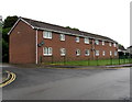
Gelligroes Road flats, Pontllanfraith
Entrance on the right.
Image: © Jaggery
Taken: 20 Jun 2018
0.06 miles
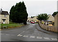
7
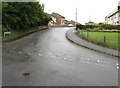
Up Gelligroes Road, Pontllanfraith
Gelligroes Road ascends from Gelli Lane.
Image: © Jaggery
Taken: 20 Jun 2018
0.06 miles
8
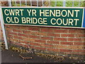
Welsh/English name sign on a Pontllanfraith corner
Located here, https://www.geograph.org.uk/photo/5820439 the sign shows that Old Bridge Court is Cwrt yr Henbont in Welsh.
Image: © Jaggery
Taken: 20 Jun 2018
0.07 miles
9
Royal Mail drop box, Gelli Lane, Pontllanfraith
Image: © Jaggery
Taken: 20 Jun 2018
0.07 miles
10
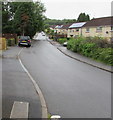
NNW along Gelli Lane, Pontllanfraith
Viewed from the corner of Marshfield Court.
Image: © Jaggery
Taken: 20 Jun 2018
0.07 miles