IMAGES TAKEN NEAR TO
Newport Road, BLACKWOOD, NP12 2JN
Introduction
This page details the photographs taken nearby to Newport Road, NP12 2JN by members of the Geograph project.
The Geograph project started in 2005 with the aim of publishing, organising and preserving representative images for every square kilometre of Great Britain, Ireland and the Isle of Man.

There are currently over 7.5m images from over14,400 individuals and you can help contribute to the project by visiting https://www.geograph.org.uk
Image Map
Images are licensed for reuse under creativecommons.org/licenses/by-sa/2.0
Notes
- Clicking on the map will re-center to the selected point.
- The higher the marker number, the further away the image location is from the centre of the postcode.
Image Listing (100 Images Found)
Images are licensed for reuse under creativecommons.org/licenses/by-sa/2.0
Image
Details
Distance
1
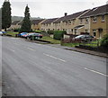
West side of Newport Road, Pontllanfraith
Houses on the west side of the B4251 Newport Road.
Image: © Jaggery
Taken: 20 Jun 2018
0.01 miles
2
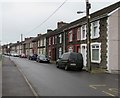
Long row of houses, Gelligroes Road, Pontllanfraith
Looking to the NE in the direction of Clos Trefin and the B4251.
Image: © Jaggery
Taken: 20 Jun 2018
0.04 miles
3
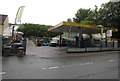
Five Star Hand Car Wash, Pontllanfraith
Located in Gelli Garage, Sir Ivors Road.
Image: © Jaggery
Taken: 20 Jun 2018
0.04 miles
4
Star Hand Car Wash and RVS Exhausts, Pontllanfraith
Car wash and car exhaust specialists located in Gelli Garage, Newport Road.
Image: © Jaggery
Taken: 23 Jan 2011
0.04 miles
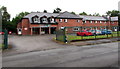
5
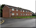
Ty-Mynyddislwyn, Gelligroes Road, Pontllanfraith
Managed by Caerphilly County Borough Council, Ty-Mynyddislwyn is
retirement/sheltered housing containing 28 1-bedroom flats built in 1984.
Image: © Jaggery
Taken: 20 Jun 2018
0.05 miles
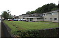
6
Millbrook Residential Home, Pontllanfraith
Purpose-built care home set back from Gelligroes Road.
Image: © Jaggery
Taken: 20 Jun 2018
0.08 miles
7
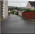
Side road from Gelligroes Road towards Overdene, Pontllanfraith
A Western Power Distribution electricity substation https://www.geograph.org.uk/photo/5820474 is behind the hedge on the right.
Image: © Jaggery
Taken: 20 Jun 2018
0.08 miles
8
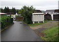
Gelligroes Housing Site electricity substation Pontllanfraith
The grey cabinet alongside the side road from Gelligroes Road to Overdene
is a Western Power Distribution electricity substation. Its identifier is S/S 551511
Image: © Jaggery
Taken: 20 Jun 2018
0.09 miles
9
Gelligroes Road flats, Pontllanfraith
Entrance on the right.
Image: © Jaggery
Taken: 20 Jun 2018
0.09 miles
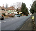
10
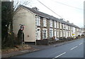
Houses, Sir Ivor's Road, Pontllanfraith
A long row of houses on the west side of the road. Some references state that this is the A4048; others show it as the B4251.
Image: © Jaggery
Taken: 23 Jan 2011
0.09 miles