1
Sir Ivors Road houses, Pontllanfraith
Looking NNE along the B4251 Sir Ivors Road from the corner of Penllwyn Avenue.
Sir Ivors Road is the name used on the local council's website.
Maps also show Sir Ivor Road and Sir Ivor's Road.
Image: © Jaggery
Taken: 20 Jun 2018
0.01 miles
2
InfoQuest, Pontllanfraith
Youth centre and cyber cafe, Sir Ivor's Road.
InfoQuest provides a drop-in service for young people, similar to a traditional youth club, although the main focus is on providing information and support. InfoQuest is part of the Basement Youth Information Network.
Image: © Jaggery
Taken: 23 Jan 2011
0.01 miles
3
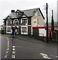
Derelict former Tredegar Junction pub, Commercial Street, Pontllanfraith
Ground floor windows are boarded up in June 2018. https://www.geograph.org.uk/photo/5814111 to a broader view. The name of the pub is a reminder that there were formerly two railway stations nearby, Pontllanfraith Low Level and Pontllanfraith High Level. Both were closed in the 1960s.
Image: © Jaggery
Taken: 20 Jun 2018
0.04 miles
4
Former Tredegar Junction pub, Commercial Street, Pontllanfraith
Viewed from the corner of Gelligroes Road in June 2018. Ground floor windows are boarded up. https://www.geograph.org.uk/photo/5814096 to a closer view. The name of the pub is a reminder that there were formerly two railway stations nearby, Pontllanfraith Low Level and Pontllanfraith High Level. Both were closed in the 1960s.
Image: © Jaggery
Taken: 20 Jun 2018
0.04 miles
5
Colin's Fish Bar, Pontllanfraith
Situated in Commercial Street.
Built on a hillside overlooking the Sirhowy Valley.
Image: © Robin Drayton
Taken: 26 May 2011
0.04 miles
6
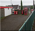
Reds on and near Ladbrokes, Pontllanfraith
Red nameboard, two red waste bins, red pillarbox, red phonebox and red Royal Mail van https://www.geograph.org.uk/photo/5813985 in the background. Located at the southern end of the former Tredegar Junction Hotel, this licensed betting shop is operated by Ladbrokes Betting & Gaming Limited (trading as Ladbrokes), based in Imperial House, Imperial Drive, Harrow.
Image: © Jaggery
Taken: 20 Jun 2018
0.04 miles
7
Colins Fish Bar
This does seem rather precarious and those legs look awfully thin.
Image: © Stuart Wilding
Taken: 11 Mar 2007
0.04 miles
8
Gelligroes Road bungalow, Pontllanfraith
A Ladbrokes betting shop https://www.geograph.org.uk/photo/5814017 is on the left.
Image: © Jaggery
Taken: 20 Jun 2018
0.05 miles
9
Pontllanfraith Ex Servicemen's Club and Institute
Located on Commercial Street.
Image: © Jaggery
Taken: 20 Jan 2011
0.05 miles
10
Royal Mail van, Gelligroes Road, Pontllanfraith
The van's identifier BW17 shows that it is based at Blackwood Delivery Office.
Image: © Jaggery
Taken: 20 Jun 2018
0.05 miles


