IMAGES TAKEN NEAR TO
Gelligroes, Pontllanfraith, BLACKWOOD, NP12 2JD
Introduction
This page details the photographs taken nearby to NP12 2JD by members of the Geograph project.
The Geograph project started in 2005 with the aim of publishing, organising and preserving representative images for every square kilometre of Great Britain, Ireland and the Isle of Man.

There are currently over 7.5m images from over14,400 individuals and you can help contribute to the project by visiting https://www.geograph.org.uk
Image Map
Images are licensed for reuse under creativecommons.org/licenses/by-sa/2.0
Notes
- Clicking on the map will re-center to the selected point.
- The higher the marker number, the further away the image location is from the centre of the postcode.
Image Listing (79 Images Found)
Images are licensed for reuse under creativecommons.org/licenses/by-sa/2.0
Image
Details
Distance
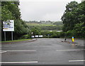
2
Junction of Gelli Lane and Newport Road, Pontllanfraith
Gelli Lane from the right joins the B4251 Newport Road.
The brown sign on the left pointing towards Gelli Lane shows Islwyn Indoor Bowls Centre.
Image: © Jaggery
Taken: 20 Jun 2018
0.05 miles
3
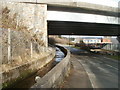
Concrete channel under A472, Gelligroes
In Gelligroes, near the southern edge of Pontllanfraith, a concrete channel passes under the bridge carrying the A472. A correspondent has told me that this channel is part of the system that fed water to power the waterwheel at the old mill http://www.geograph.org.uk/photo/2247440. The start of the system is about 300 metres north of the path that connects Sir Ivor Road with Springfield.
Visible in the middle distance is a white building in Blackwood Business Park. http://www.geograph.org.uk/photo/2247409
Image: © Jaggery
Taken: 23 Jan 2011
0.05 miles
4
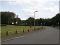
Benches under trees near Gelli Lane, Pontllanfraith
Set back from the south side of Gelli Lane.
Image: © Jaggery
Taken: 20 Jun 2018
0.05 miles
5
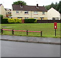
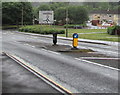
Queen Elizabeth II postbox, Gelli Lane, Pontllanfraith
Viewed from the corner of Marshfield Court.
Image: © Jaggery
Taken: 20 Jun 2018
0.07 miles
6
Welcome to Hawker Siddeley Switchgear, Pontllanfraith
The Welcome sign faces the B4251 Newport Road.
Image: © Jaggery
Taken: 20 Jun 2018
0.07 miles
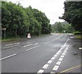
7
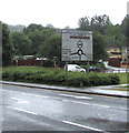
Gelligroes Roundabout direction sign, Pontllanfraith
Facing southbound traffic on the B4251 Newport Road 150 metres from the roundabout.
Image: © Jaggery
Taken: 20 Jun 2018
0.07 miles
8
Southern boundary of Pontllanfraith
Viewed across Newport Road (A4048). The white-on-green Pontllanfraith sign is on the corner of Gelli Lane.
Image: © Jaggery
Taken: 23 Jan 2011
0.08 miles
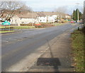
9
Pedestrian refuge, Newport Road, Pontllanfraith
Walkers can use the refuge to cross half a road width at a time when traffic is busy on the B4251 Newport Road.
Image: © Jaggery
Taken: 20 Jun 2018
0.08 miles
10
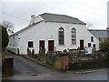
Siloh Presbyterian Church, Gelligroes
Erected in 1813.
Siloh (Shiloh) is a biblical place name as recorded in Judges 18:1 "The whole assembly of the Israelites gathered at Shiloh and set up the Tent of Meeting there."
Image: © Robin Drayton
Taken: 20 Mar 2010
0.08 miles