IMAGES TAKEN NEAR TO
Glanhowy Road, BLACKWOOD, NP12 2HN
Introduction
This page details the photographs taken nearby to Glanhowy Road, NP12 2HN by members of the Geograph project.
The Geograph project started in 2005 with the aim of publishing, organising and preserving representative images for every square kilometre of Great Britain, Ireland and the Isle of Man.

There are currently over 7.5m images from over14,400 individuals and you can help contribute to the project by visiting https://www.geograph.org.uk
Image Map
Images are licensed for reuse under creativecommons.org/licenses/by-sa/2.0
Notes
- Clicking on the map will re-center to the selected point.
- The higher the marker number, the further away the image location is from the centre of the postcode.
Image Listing (53 Images Found)
Images are licensed for reuse under creativecommons.org/licenses/by-sa/2.0
Image
Details
Distance
1
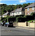
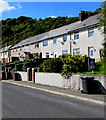
Wyllie houses
Semi-detached houses set above Glanhowy Road in Wyllie.
Image: © Jaggery
Taken: 24 Sep 2018
0.01 miles
2
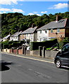
Glanhowy Road semis, Wyllie
Semi-detached houses set above road level.
Image: © Jaggery
Taken: 24 Sep 2018
0.02 miles
5
Row of houses in Wyllie
Above Glanhowy Road, Wyllie.
Image: © Jaggery
Taken: 24 Sep 2018
0.04 miles
6
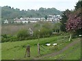
View across the Sirhowy Valley
The view from Pontgam Terrace http://www.geograph.org.uk/photo/2372100 looking across the valley to Wyllie.
For the view back across the valley see http://www.geograph.org.uk/photo/2327296 .
The River Sirhowy and the B4251 are hidden in the valley.
Image: © Robin Drayton
Taken: 22 Apr 2011
0.04 miles
7
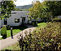
Entrance to Coed y Cwm, Wyllie
Located below the east side of Glenhowy Road, Coed y Cwm is
a community day centre for people with learning difficulties.
Image: © Jaggery
Taken: 24 Sep 2018
0.05 miles
8
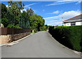
North along Pen-y-Cwarel Road, Wyllie
Viewed from the edge of The Glade. https://www.geograph.org.uk/photo/5920930
Image: © Jaggery
Taken: 24 Sep 2018
0.07 miles
9
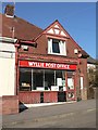
Wyllie: post office
This post office is threatened with closure in the spring of 2008. This was a classic candidate to join 2,500 others in the UK this year, open 10 hours a week, reporting weekly custom of fewer than 50 transactions per week, and within 1½ miles of two alternative branches.
Image: © Chris Downer
Taken: 16 Feb 2008
0.07 miles
10
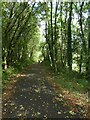
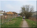
NCN47 south of Wyllie in Sirhowy Valley Country Park
Image: © David Smith
Taken: 27 Sep 2021
0.07 miles