IMAGES TAKEN NEAR TO
Wyllie, BLACKWOOD, NP12 2HH
Introduction
This page details the photographs taken nearby to NP12 2HH by members of the Geograph project.
The Geograph project started in 2005 with the aim of publishing, organising and preserving representative images for every square kilometre of Great Britain, Ireland and the Isle of Man.

There are currently over 7.5m images from over14,400 individuals and you can help contribute to the project by visiting https://www.geograph.org.uk
Image Map
Images are licensed for reuse under creativecommons.org/licenses/by-sa/2.0
Notes
- Clicking on the map will re-center to the selected point.
- The higher the marker number, the further away the image location is from the centre of the postcode.
Image Listing (49 Images Found)
Images are licensed for reuse under creativecommons.org/licenses/by-sa/2.0
Image
Details
Distance
1
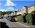
Tirbach Road houses, Wyllie
Above Glanhowy Road.
Image: © Jaggery
Taken: 24 Sep 2018
0.03 miles
2
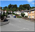
The Avenue, Wyllie
Ascending from Glanhowy Road.
Image: © Jaggery
Taken: 24 Sep 2018
0.06 miles
3
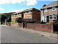
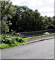
West side of Glanhowy Road, Wyllie
These houses above the west side of Glanhowy Road are near a bus stop https://www.geograph.org.uk/photo/5917494 for buses to Blackwood.
Image: © Jaggery
Taken: 24 Sep 2018
0.09 miles
4
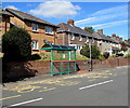
Glanhowy Road bus stop and shelter, Wyllie
The stop near the corner of The Avenue is on bus route 6 to Blackwood bus station via Gelligroes and Pontllanfraith. In September 2018 buses on this route are operated by Harris Coaches.
Image: © Jaggery
Taken: 24 Sep 2018
0.09 miles
5
Bilingual sign - Playground/Lle chwarae, Glanhowy Road, Wyllie
The English/Welsh sign is above this https://www.geograph.org.uk/photo/5917411 children's playground.
Image: © Jaggery
Taken: 24 Sep 2018
0.09 miles
6
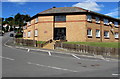
Marion Jones Court, Wyllie
Managed by Derwen Cymru, Marion Jones Court is retirement housing built in 1993.
This part of Marion Jones Court, on the corner of The Avenue and Glanhowy Road,
was formerly occupied by Wyllie Methodist Chapel.
Image: © Jaggery
Taken: 24 Sep 2018
0.09 miles
7
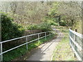
Across a bridge over a former railway line south of Pontllanfraith
A cycle route and footpath cross this http://www.geograph.org.uk/photo/2839694 bridge.
Image: © Jaggery
Taken: 7 Apr 2011
0.09 miles
8
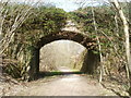
SE side of a bridge across a former railway line south of Pontllanfraith
The bridge formerly carried a minor road across a railway from Pontllanfraith to Ynysddu and beyond. The railway trackbed is now a cycle route and footpath.
Image: © Jaggery
Taken: 7 Apr 2011
0.09 miles
9
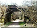
NW side of a bridge across a former railway line south of Pontllanfraith
The bridge formerly carried a minor road across a railway from Pontllanfraith to Ynysddu and beyond. The railway trackbed is now a cycle route and footpath.
Image: © Jaggery
Taken: 7 Apr 2011
0.09 miles
10
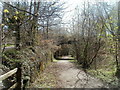
Cycle route and footpath formerly a railway line south of Pontllanfraith
This was formerly a Sirhowy valley railway line from Pontllanfraith to Ynysddu and beyond, following a route above, and slightly west of, Newport Road.
Image: © Jaggery
Taken: 7 Apr 2011
0.09 miles