IMAGES TAKEN NEAR TO
Cwm Braenar, BLACKWOOD, NP12 2DS
Introduction
This page details the photographs taken nearby to Cwm Braenar, NP12 2DS by members of the Geograph project.
The Geograph project started in 2005 with the aim of publishing, organising and preserving representative images for every square kilometre of Great Britain, Ireland and the Isle of Man.

There are currently over 7.5m images from over14,400 individuals and you can help contribute to the project by visiting https://www.geograph.org.uk
Image Map
Images are licensed for reuse under creativecommons.org/licenses/by-sa/2.0
Notes
- Clicking on the map will re-center to the selected point.
- The higher the marker number, the further away the image location is from the centre of the postcode.
Image Listing (29 Images Found)
Images are licensed for reuse under creativecommons.org/licenses/by-sa/2.0
Image
Details
Distance
1
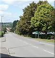
Pontllanfraith boundary sign
Shaded by trees, a green sign asks you to please drive carefully in Pontllanfraith.
Behind the trees is a Sainsbury's superstore. http://www.geograph.org.uk/photo/2016911 Behind the camera are newly-built flats.
http://www.geograph.org.uk/photo/2016947
Image: © Jaggery
Taken: 16 Aug 2010
0.04 miles
2
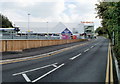
Perimeter road, Sainsbury's, Pontllanfraith
The road, on the southern edge of the Newbridge Road site, leads from the superstore to the filling station http://www.geograph.org.uk/photo/2016897 and exit.
Image: © Jaggery
Taken: 16 Aug 2010
0.04 miles
3
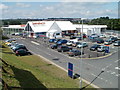
Sainsbury's Pontllanfraith
The superstore opened in 2009 on a site on the north side of Newbridge Road formerly occupied by a Somerfield store.
Image: © Jaggery
Taken: 16 Aug 2010
0.04 miles
4
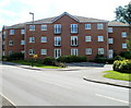
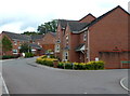
Modern flats, Newbridge Road, Pontllanfraith
Located on the south side of the road, opposite Sainsbury's. http://www.geograph.org.uk/photo/2016911
Image: © Jaggery
Taken: 16 Aug 2010
0.05 miles
5
Gilwern House care home, Pontllanfraith
Privately-owned care home accommodating 13 residents, located on Newbridge Road.
Image: © Jaggery
Taken: 16 Aug 2010
0.05 miles
6
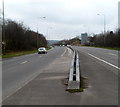
Along the central barrier of the A472 towards Ystrad Mynach
Viewed from the edge of a roundabout in Pontllanfraith.
Image: © Jaggery
Taken: 16 Mar 2012
0.07 miles
7
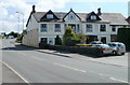
Cwm Braenar, Pontllanfraith
Cwm Braenar houses viewed from the corner of Vicarage Lane.
Image: © Jaggery
Taken: 8 Aug 2012
0.09 miles
8
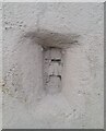
Ordnance Survey Flush Bracket (S9918)
This OS Flush Bracket can be found on Gilwern House. It marks a point 157.286m above mean sea level.
Image: © Adrian Dust
Taken: 9 Feb 2021
0.09 miles
9
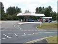
Sainsbury's filling station, Pontllanfraith
Located at the western end of Sainsbury's superstore http://www.geograph.org.uk/photo/2016911 which opened on the former Somerfield site on the north side of Newbridge Road in 2009.
Image: © Jaggery
Taken: 16 Aug 2010
0.10 miles
10
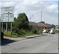
Newbridge Road heading west away from Pentwynmawr
A few metres behind the camera, High Street Pentwynmawr is renamed Newbridge Road on leaving the village. Straight ahead (around the roundabout) for Pontllanfraith http://www.geograph.org.uk/photo/2016959 and Sainsbury's. http://www.geograph.org.uk/photo/2016911
Image: © Jaggery
Taken: 16 Aug 2010
0.10 miles