IMAGES TAKEN NEAR TO
Woodfieldside Business Park, Penmaen Road, BLACKWOOD, NP12 2DG
Introduction
This page details the photographs taken nearby to Woodfieldside Business Park, Penmaen Road, NP12 2DG by members of the Geograph project.
The Geograph project started in 2005 with the aim of publishing, organising and preserving representative images for every square kilometre of Great Britain, Ireland and the Isle of Man.

There are currently over 7.5m images from over14,400 individuals and you can help contribute to the project by visiting https://www.geograph.org.uk
Image Map
Images are licensed for reuse under creativecommons.org/licenses/by-sa/2.0
Notes
- Clicking on the map will re-center to the selected point.
- The higher the marker number, the further away the image location is from the centre of the postcode.
Image Listing (28 Images Found)
Images are licensed for reuse under creativecommons.org/licenses/by-sa/2.0
Image
Details
Distance
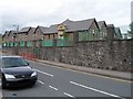
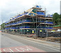
1
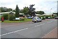
Woodfieldside Business Park, Pontllanfraith
Viewed from the entrance road from Penmaen Road.
The business units were partly funded through the European Objective 1 Programme and the Local Regeneration Fund via the Welsh Government. The business park contains 22 business units, designed for light industrial use.
Image: © Jaggery
Taken: 8 Aug 2012
0.05 miles
3
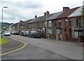
Penmaen Road houses near a new section of the B4251
Residents of this row of houses have a somewhat quieter existence since the course of the B4251 was moved a few metres to the east, along this http://www.geograph.org.uk/photo/3074149 recently-built road.
Image: © Jaggery
Taken: 8 Aug 2012
0.10 miles
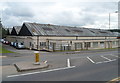
4
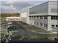
Hawtin Park, Blackwood
Photo shows the Seda plant.
Image: © Kev Griffin
Taken: 16 Nov 2004
0.12 miles
5
Pontllanfraith Primary School
Viewed across Penmaen Road. The Infants part of the school is on the right.
Image: © Jaggery
Taken: 8 Aug 2012
0.13 miles
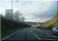
6
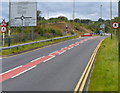
No pedestrians ahead on the B4251, Pontllanfraith
This recently-built section of road has no provision for pedestrians,
who are forbidden to proceed beyond the red-edged circular signs.
Pedestrians can use the old course of Penmaen Road nearby.
Image: © Jaggery
Taken: 8 Aug 2012
0.13 miles
7
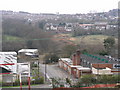
South end of Blackwood by-pass
View from Pontllanfraith across to Blackwood as clearance work started on southern cross valley link
Image: © Steve Morgan
Taken: 11 Apr 2004
0.14 miles
8
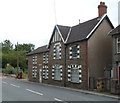
Riverside House, Pontllanfraith
Distinctive detached house in Penmaen Road.
Image: © Jaggery
Taken: 8 Aug 2012
0.16 miles
9
House construction, Nant y coed, Pontllanfraith
Part of a Charles Church construction site located opposite recently-built houses
in Maes-yr-afon and Pleasant Close. http://www.geograph.org.uk/photo/3074372
Image: © Jaggery
Taken: 8 Aug 2012
0.16 miles
10
Stagecoach depot, Pontllanfraith
Located on the corner of Penmaen Road and the B4254, this was formerly the depot and offices of Islwyn Borough Transport, which provided bus services in Blackwood and surrounding areas from 1974 to 2010.
Image: © Jaggery
Taken: 8 Aug 2012
0.18 miles