IMAGES TAKEN NEAR TO
Brynglas Avenue, BLACKWOOD, NP12 2DD
Introduction
This page details the photographs taken nearby to Brynglas Avenue, NP12 2DD by members of the Geograph project.
The Geograph project started in 2005 with the aim of publishing, organising and preserving representative images for every square kilometre of Great Britain, Ireland and the Isle of Man.

There are currently over 7.5m images from over14,400 individuals and you can help contribute to the project by visiting https://www.geograph.org.uk
Image Map
Images are licensed for reuse under creativecommons.org/licenses/by-sa/2.0
Notes
- Clicking on the map will re-center to the selected point.
- The higher the marker number, the further away the image location is from the centre of the postcode.
Image Listing (87 Images Found)
Images are licensed for reuse under creativecommons.org/licenses/by-sa/2.0
Image
Details
Distance
1
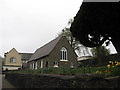
Sacred Heart RC Church
Sacred Heart Roman Catholic Church in Pontllanfraith, with churchyard flowers adding some colour on rainy afternoon. The white-painted window surrounds give the church an attractive appearance.
Image: © David Roberts
Taken: 20 Apr 2008
0.07 miles
2
Green's Fishing Tackle, Pontllanfraith
Specialist shop on the corner of Bryn Road and Manor Road.
Image: © Jaggery
Taken: 24 May 2011
0.07 miles
3
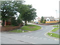
Manor Road, Pontllanfraith
Viewed from Bryn Road.
Image: © Jaggery
Taken: 24 May 2011
0.07 miles
4
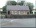
Sacred Heart, Pontllanfraith
Roman Catholic church, Blackwood Road, facing a roundabout at the junction with Commercial Street, Bryn Road and Gelligroes Road. Built in 1853-1854, the church was modernised at the start of the 21st century.
Image: © Jaggery
Taken: 24 May 2011
0.09 miles
5
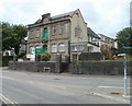
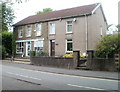
Groundwork Caerphilly premises, Pontllanfraith
Grade II listed building, Bryn Road, Pontllanfraith. Inscribed in stone across the top of the building is
MYNYDDISLWYN URBAN DISTRICT COUNCIL OFFICES, with the year 1913 in the centre, between URBAN and DISTRICT.
Mynyddislwyn UDC ceased to exist following the 1974 local government reforms.
Groundwork Caerphilly is a charity which helps people and organisations make changes in order to create better neighbourhoods, to build skills and job prospects, and to live and work in a greener way. It is part of Groundwork in Wales, a local, regional and national environmental regeneration network building sustainable communities in Wales.
Image: © Jaggery
Taken: 24 May 2011
0.09 miles
6
The Bird in Hand, Bryn Rd, Pontllanfraith
Image: © John Lord
Taken: 24 Aug 2017
0.09 miles
7
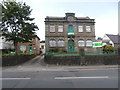
The former Mynyddislwyn Urban District Council Offices
Image: © John Lord
Taken: 24 Aug 2017
0.10 miles
8
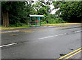
Bryn Road bus stop and shelter, Pontllanfraith
In June 2018 the bus stop sign shows that this is a stop on four bus routes -
7 to Pontypridd, 9 to Penllwyn, 26 to Cardiff, 901 to Ystrad Mynach railway station.
Image: © Jaggery
Taken: 20 Jun 2018
0.10 miles
9
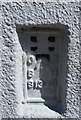
Ordnance Survey Flush Bracket (S1340)
This OS Flush Bracket can be found on the SW face of the RC Church. It marks a point 156.323m above mean sea level.
Image: © Adrian Dust
Taken: 22 Jun 2019
0.10 miles
10
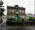
Former Mynyddislwyn Urban District Council Offices, Bryn Road, Pontllanfraith
MYNYDDISLWYN URBAN DISTRICT COUNCIL OFFICES 1913 is embossed on the wall at the top of the Grade II listed building. Mynyddislwyn UDC ceased to exist following the 1974 local government reforms.
In June 2018, these are the offices of Groundwork Wales, a charity which helps people and organisations make changes in order to create better neighbourhoods, to build skills and job prospects, and to live and work in a greener way.
Image: © Jaggery
Taken: 20 Jun 2018
0.11 miles