IMAGES TAKEN NEAR TO
Coed-Cae-Ddu Road, BLACKWOOD, NP12 2DA
Introduction
This page details the photographs taken nearby to Coed-Cae-Ddu Road, NP12 2DA by members of the Geograph project.
The Geograph project started in 2005 with the aim of publishing, organising and preserving representative images for every square kilometre of Great Britain, Ireland and the Isle of Man.

There are currently over 7.5m images from over14,400 individuals and you can help contribute to the project by visiting https://www.geograph.org.uk
Image Map
Images are licensed for reuse under creativecommons.org/licenses/by-sa/2.0
Notes
- Clicking on the map will re-center to the selected point.
- The higher the marker number, the further away the image location is from the centre of the postcode.
Image Listing (69 Images Found)
Images are licensed for reuse under creativecommons.org/licenses/by-sa/2.0
Image
Details
Distance
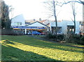
1
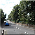
Penllwyn Lane, Pontllanfraith
Penllwyn Lane heads SW away from Blackwood Road.
Image: © Jaggery
Taken: 22 Aug 2013
0.06 miles
2
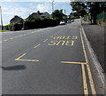
Penllwyn Lane bus stops, Pontllanfraith
The bus stops are opposite Brynteg Avenue. http://www.geograph.org.uk/photo/3615792 Pontllanfraith Comprehensive School is nearby.
Image: © Jaggery
Taken: 22 Aug 2013
0.06 miles
3
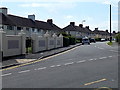
Brynteg Avenue, Pontllanfraith
Houses on the east side of Brynteg Avenue, viewed across Penllwyn Lane.
Image: © Jaggery
Taken: 22 Aug 2013
0.11 miles
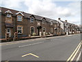
4
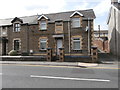
House in Blackwood Rd, Pontllanfraith
The date 1893 is prominently displayed in the brickwork panel above the door.
Image: © John Lord
Taken: 24 Aug 2017
0.12 miles
5
Wat Will Motor Company, Pontllanfraith
Used car premises located on the corner of Blackwood Road and Brynhyfryd Street, Pontllanfraith.
Image: © Jaggery
Taken: 20 Jan 2011
0.13 miles
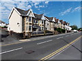
6
Houses in Blackwood Rd, Pontllanfraith
Each house has the date 1893 above the door.
Image: © John Lord
Taken: 24 Aug 2017
0.13 miles
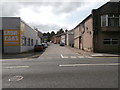
7
Semi-detached houses, Blackwood Road, Pontllanfraith
The houses are in the NE of Pontllanfraith near the Blackwood boundary.
Image: © Jaggery
Taken: 22 Aug 2013
0.13 miles
9
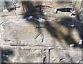
Ordnance Survey Cut Mark
This OS cut mark can be found on the old school wall at the road junction. It marks a point 156.546m above mean sea level.
Image: © Adrian Dust
Taken: 22 Jun 2019
0.14 miles
10
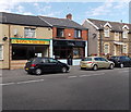
Wong's Chinese Takeaway and Plaitform No.5 Hair Studio, Pontllanfraith
The takeaway on the left and hair studio next door are in Station Buildings, Blackwood Road, Pontllanfraith. Railway passenger services in this area ended in the early 1960s.
Image: © Jaggery
Taken: 22 Aug 2013
0.15 miles