IMAGES TAKEN NEAR TO
Pontllanfraith, BLACKWOOD, NP12 2AP
Introduction
This page details the photographs taken nearby to NP12 2AP by members of the Geograph project.
The Geograph project started in 2005 with the aim of publishing, organising and preserving representative images for every square kilometre of Great Britain, Ireland and the Isle of Man.

There are currently over 7.5m images from over14,400 individuals and you can help contribute to the project by visiting https://www.geograph.org.uk
Image Map
Images are licensed for reuse under creativecommons.org/licenses/by-sa/2.0
Notes
- Clicking on the map will re-center to the selected point.
- The higher the marker number, the further away the image location is from the centre of the postcode.
Image Listing (23 Images Found)
Images are licensed for reuse under creativecommons.org/licenses/by-sa/2.0
Image
Details
Distance
1
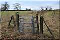
Gate on path to Twynfilkins Farm
Kissing gate giving onto the public footpath across the field. The far end of the path is overgrown where it leaves the field.
Image: © M J Roscoe
Taken: 1 Jan 2019
0.06 miles
2
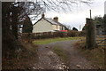
Twynfilkins Cottage
The first part of the driveway carries a public footpath to a kissing gate to the right of the drive.
Image: © M J Roscoe
Taken: 1 Jan 2019
0.08 miles
3
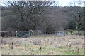
Corner of field near Twynfilkins Cottage
The gate on the left opens almost onto the road. The footpath kissing gate Image opens onto the drive to the cottage, but the OS map shows the public footpath starting directly from the road.
Image: © M J Roscoe
Taken: 1 Jan 2019
0.08 miles
4
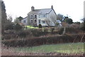
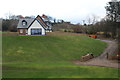
Houses, Tir Philkins
Houses on a slight rise opposite Tir-Philkins Farm.
Image: © M J Roscoe
Taken: 11 Feb 2016
0.09 miles
5
Tir-Filkins Farm
Rebuilt farmhouse and driveway. A public footpath runs across the bottom of the picture.
Image: © M J Roscoe
Taken: 1 Jan 2019
0.13 miles
6
Muddy tracks into a field, Pontllanfraith
Viewed from a lane, Tir Philkins, a few metres from the SE side of this Grade II listed bridge. http://www.geograph.org.uk/photo/3074573
Image: © Jaggery
Taken: 8 Aug 2012
0.17 miles
7
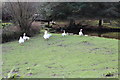
Geese at Glan-brynar Farm, Tir Philkins
Geese at large pond on well cropped grass next to the entrance to the farm in Image
Image: © M J Roscoe
Taken: 11 Feb 2016
0.17 miles
8
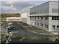
Hawtin Park, Blackwood
Photo shows the Seda plant.
Image: © Kev Griffin
Taken: 16 Nov 2004
0.18 miles
9
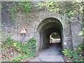
Very low bridge, Blackwood
The railway which once crossed this bridge has long gone.
The Sirhowy Enterprise Way http://www.geograph.org.uk/photo/1570820 , which was built on the line of the railway, was routed a little to the west at this point thus leaving this bridge standing.
Image: © Robin Drayton
Taken: 8 Oct 2009
0.19 miles
10
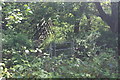
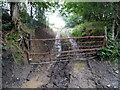
Footbridge over Nant Philkins
Gate and bridge on public footpath towards Tir-Filkins Farm.
Image: © M J Roscoe
Taken: 19 May 2020
0.19 miles