IMAGES TAKEN NEAR TO
Attlee Road, BLACKWOOD, NP12 1QE
Introduction
This page details the photographs taken nearby to Attlee Road, NP12 1QE by members of the Geograph project.
The Geograph project started in 2005 with the aim of publishing, organising and preserving representative images for every square kilometre of Great Britain, Ireland and the Isle of Man.

There are currently over 7.5m images from over14,400 individuals and you can help contribute to the project by visiting https://www.geograph.org.uk
Image Map
Images are licensed for reuse under creativecommons.org/licenses/by-sa/2.0
Notes
- Clicking on the map will re-center to the selected point.
- The higher the marker number, the further away the image location is from the centre of the postcode.
Image Listing (212 Images Found)
Images are licensed for reuse under creativecommons.org/licenses/by-sa/2.0
Image
Details
Distance
1
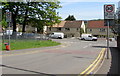
From 20 to 30 on Apollo Way, Blackwood
The 20mph speed limit in force near Blackwood Primary School
increases to 30mph on the approach to the Attlee Road junction.
Image: © Jaggery
Taken: 17 May 2018
0.03 miles
2
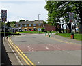
From 30 to 20 on Apollo Way, Blackwood
Near a speed bump, the 30mph speed limit drops to 20mph on the approach to Blackwood Primary School. PARTH is Welsh for ZONE. The green cones mark the Keep Clear Zone (no stopping or parking) near the school.
Image: © Jaggery
Taken: 17 May 2018
0.03 miles
3
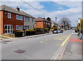
Albany Road and Attlee Road, Blackwood
A view along Albany Road into Attlee Road. The right turn just past
the bus stop into Woodbine Road is the point at which the name change occurs.
Image: © Jaggery
Taken: 1 May 2013
0.04 miles
4
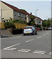
Southern end of Morrison Street, Blackwood
Viewed from the corner of Woodbine Road and Coronation Road.
Image: © Jaggery
Taken: 17 May 2018
0.04 miles
5
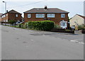
Semis on a Blackwood corner
Semi-detached houses on the corner of Woodbine Road and Morrison Street.
Image: © Jaggery
Taken: 17 May 2018
0.04 miles
6
Two rows of green cones, Apollo Way, Blackwood
The cones mark the no parking/no stopping zone near the entrance to Blackwood Primary School.
Image: © Jaggery
Taken: 17 May 2018
0.05 miles
7
Wires over Woodbine Road, Blackwood
Telephone wires radiate from a pole on the corner of Woodbine Road and Morrison Street.
Image: © Jaggery
Taken: 17 May 2018
0.05 miles
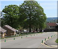
8
Apollo Way bungalows set below road level, Blackwood
Originally, bungalow was used in English for a lightly-built house, with a veranda and one storey.
In current UK usage it is a convenient word for any one-storey dwelling.
The green cones are part of the Keep Clear Zone (no stopping or parking) near Blackwood Primary School.
Image: © Jaggery
Taken: 17 May 2018
0.05 miles
9
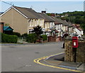
Queen Elizabeth II postbox, Coronation Road, Blackwood
On the corner of Woodbine Road at the northern end of Coronation Road
Image: © Jaggery
Taken: 17 May 2018
0.05 miles
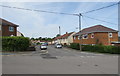
10
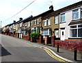
Woodbine Road houses, Blackwood
West of the Woodbine Close junction.
Image: © Jaggery
Taken: 17 May 2018
0.06 miles